
In the United States alone, there are currently over 100,000 miles of canal and levee embankments and approximately 79,000 earthen dams on the national inventory list. Many of these structures are reaching or have surpassed their initial design life. Most earthen embankment structures are over 50 years old, and many are greater than 80 years old. Development and urban encroachment along this aging infrastructure increase risk associated with seepage and internal erosion-caused failures. Additionally, water conveyance systems are known to lose large quantities of water due to distributed seepage along embankments. As a result, there is a need for proactive yet efficient characterization of these vast infrastructural systems by means of rapid reconnaissance surveying technologies.
To address these issues, researchers at BOR are working with three area offices (Provo Area Office, Lahontan Basin Area Office, and Western Colorado Area Office) to develop new approaches for rapid earthen canal and levee seepage detection and characterization. One new approach uses remote sensing data, including Normalized Difference Vegetative Index (NDVI) images, combined with frequency-domain electromagnetic (FDEM) and magnetic gradiometry profiling surveys conducted along canal embankments using a vehicle-towed non-magnetic/non-metallic cart platform. This approach to field data collection allows for tens of miles of detailed geophysical profiling data to be collected per day.
The research team has been funded through BOR’s Science and Technology Program and is working toward developing semi-automated and robust workflows for combining and interpreting these various data types, including data fusion, attributes analysis, and machine learning, to better identify and differentiate between anomalies related to seepage, unauthorized penetrations, or other unhealthy conditions. Implementation of rapid reconnaissance tools of this sort could provide a list of “hot spots” that could be prioritized in terms of more focused investigation efforts (e.g., using higher resolution geophysical methods or geotechnical investigation techniques at locations of elevated concern). This approach to identifying abnormal seepage or saturation levels within canal levees (based on electrical conductivity signatures/anomalies/trends) will help save a considerable amount of resources being spent on embankment assessment, reduce risk associated with embankment failures, and can help to identify and address unwanted water conveyance seepage losses.
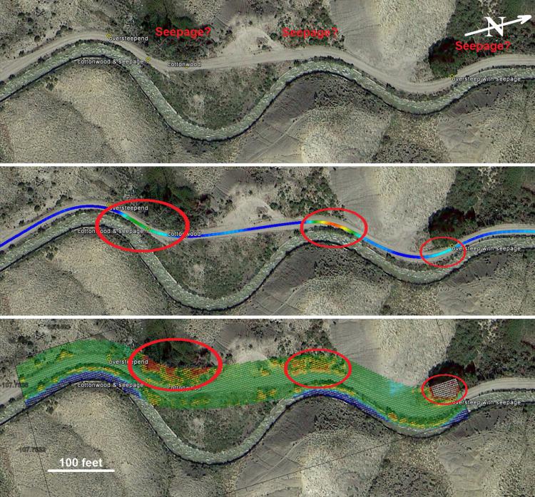
Example seepage detection data along South Canal located near Montrose, Colorado: Aerial imagery with field observation global positioning system (GPS) waypoints and three suspected seepage locations (top), overlay of EM34 apparent conductivity profiling data showing elevated conductivity anomalies (center), overlay of a 20-meter-wide swath of NDVI data along the FDEM survey profile showing elevated NDVI values attributed to lush vegetation (bottom). The visible correlation between the two data types reveals the exact locations of three seeps along the canal embankment.