
Alaska is the only Arctic State in the Nation. The Arctic environment presents some unique challenges to living, working, and operating, including a lack of road infrastructure, high costs of shipping freight, and seasonal daylight limitations during the winter. The sun drops below the horizon in November and does not rise above the horizon until mid-February.
To help Arctic communities be less isolated during the winter, the BLM Arctic District Office (RDO) authorized Community Winter Access Trails (CWAT) for public use across the National Petroleum Reserve-Alaska (NPR-A) beginning January 2019. Made from compacted snow, the CWAT is cheaper and easier to build than ice roads, but snow has a shorter operational season, only supports lower ground pressure vehicles, and is prone to soft spots where tires can get stuck. Still, the North Slope Borough has found a safe way to build and maintain the routes using tracked vehicles. Once the route sets up, it can later be used by passenger vehicles being escorted across the right of way on a weekly basis.
The RDO monitors conditions along one of the CWAT corridors using eight thermistors and acoustic sensors that provide data on soil temperature, frost depth, and snow depths. As the COVID-19 pandemic emerged, the BLM/RDO recognized travel restrictions would prevent these onsite inspections using the installed sensors. To address this limitation, BLM began acquiring Maxar/DigitalGlobe’s high-resolution WorldView imagery in early March 2020 under the NextView Contract. These images allowed RDO to remotely monitor snow conditions along the CWAT, leading to a road closure date in early May, but not before vital COVID-19 supplies and emergency freight were transported in from Prudhoe Bay to Utqiagvik, Alaska. RDO field staff used the winter imagery to identify specific sites for field surveys and monitoring activities as part of the management strategy for the right-of-way grant.
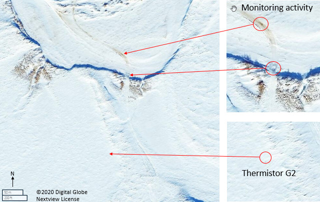
Overview of Community Wide Access Trail (CWAT) monitoring activity. Upper right: close-up of observed soft spot near river crossing. Lower Right: close-up of Thermistor G2 site location with pole casting a shadow.
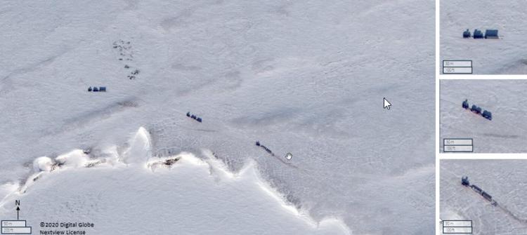
Left: A supply caravan traversing the tundra headed toward Utiagvik (formerly Barrow), Alaska, along the CWAT trail within the National Petroleum Reserve-Alaska. Right, close-up of each supply vehicle group