
The Bureau of Land Management (BLM) National Operations Center (NOC) and the Medford District Office (MDO) are using multi-scale, multi-temporal remotely sensed imagery to monitor forest cover and condition in BLM-administered lands in southwestern Oregon. The NOC employed cloud-computing architecture to efficiently derive a suite of Sentinel-2 10-meter resolution satellite image mosaic products spanning the entire MDO. Separate multispectral imagery, Normalized Difference Vegetation Index (NDVI), and Green-Red Vegetation Index (GRVI) mosaic products were developed from Sentinel-2 imagery collected during the summer and fall of 2021. The data were used to support multiple resource management objectives, including owl habitat and dry forest restoration planning, identification of shrub cover, assessment of conifer encroachment in shrubland areas, and monitoring of vegetation stress.
Follow-on applied science efforts are using commercial WorldView and Planet high-resolution satellite imaging systems, in conjunction with field observations, to quantify conifer mortality at a fine spatial scale within district office-administered forests. Drought and insect-induced conifer die-off over the past several years has been well documented. This effort may also contribute methods to facilitate mapping mortality over a larger geographic area using freely available Sentinel-2 imagery.
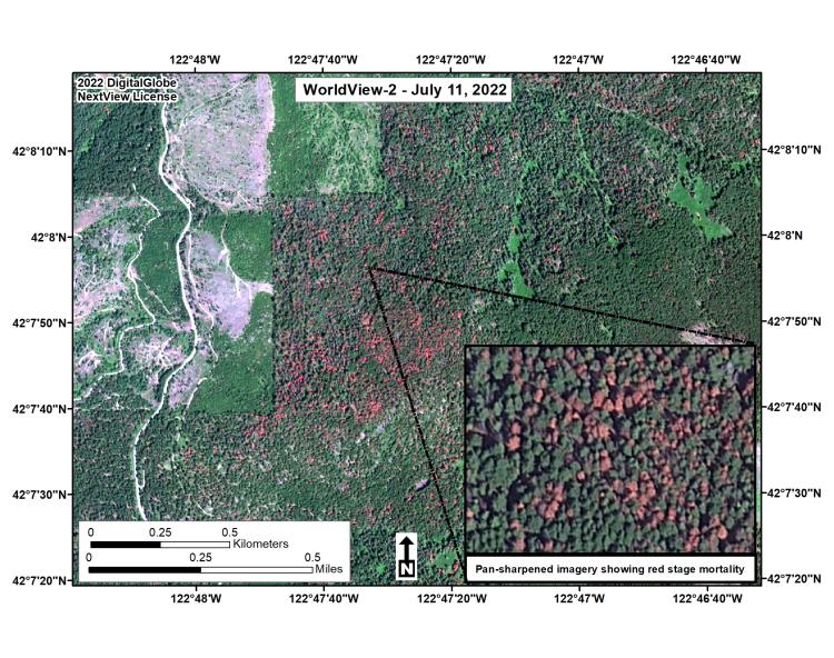
WorldView-2 high-resolution multispectral satellite imagery confirming red-stage vegetation mortality near Ashland, Oregon.
Disclaimer: Any use of trade, firm, or product names is for descriptive purposes only and does not imply endorsement by the U.S. Government.