
Glaciers are important sentinels of a changing climate, crucial components of the global cryosphere, and integral to ecosystem functioning in the surrounding landscape. Until now, commonly used methods for mapping glacier change were labor intensive and thus limited in temporal and spatial scope. This work addressed some of those limitations by developing a novel deep learning–based method called GlacierCoverNet, a deep neural network that relies on an extensive, customized training dataset. Using this model, scientists created a biannual record of glacier change across Alaska from 1985 to 2020.
The workflow consisted of a series of algorithms that create a spectrally homogenous time series of optical imagery, followed by an initial classification of debris-free and debris-covered glacier ice using a deep neural network. The initial optical imagery time series was created from the Landsat archive using the LandTrendr algorithm run on the Google Earth Engine platform. To train the deep learning model, a training dataset was built composed of predictor variables from LandTrendr outputs, topographic information, and class labels based on the Randolph Glacier Inventory.
These data characterize changes in debris-free glaciers and supraglacial debris over the last 35 years. The deep-learning model produced maps similar to those generated using existing approaches but without labor-intensive manual editing. The overall model accuracy was ~97% when compared to existing products, with ~6% and ~9% omission and commission rates in southern Alaska. Overall, glacier-covered area retreated by 8,425 square kilometers (–13%) between 1985 and 2020, and supraglacial debris expanded by 2,799 square kilometers (64%) during the same period across Alaska.
Glacier-covered area declined, and supraglacial debris increased across Alaska during the study period with the largest net glacier loss in the most heavily glaciated areas of south-central Alaska. The largest changes in overall glacier-covered area occurred in the mid elevations of 800–2,200 meters and in the last decade, as mean annual temperatures have increased more rapidly. The associated manuscript can be found here and the data collection is available here.
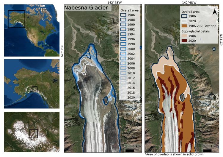
Most of North America's glaciers are in south-central Alaska, shown in the left panels in white. Biannual maps of Nabesna Glacier in Wrangell-St. Elias National Park show a decrease in total glacier-covered area (center) and an increase in debris cover on the glacier surface (right).
Disclaimer: Any use of trade, firm, or product names is for descriptive purposes only and does not imply endorsement by the U.S. Government.