
National Park Service (NPS) scientists had been monitoring water quality in a small lake in Yukon-Charley Rivers National Preserve since 2005 when they noticed a sudden and persistent increase in the ionic concentration in 2019. The specific conductance of the lake water increased over time. Examination of high-resolution WorldView-2 and Planet satellite images revealed that two small patches of dead vegetation, suspected to be new groundwater seeps, appeared at the foot of a slope near the lake in 2019. Field visits to the seeps revealed that the dead vegetation was caused by water with conductance exceeding 6,000 µS/cm, and flow paths to the lake confirmed that the seeps are the source of the ions in the lake. The images also revealed that water lilies (Nuphar lutea) disappeared from the lake coincident with the rise in conductance and in accordance with their known sensitivity to high ionic concentrations. The seeps may have formed in response to permafrost thaw that occurred due to climate warming and wildfires in the lake's watershed. The associated manuscript can be found here.
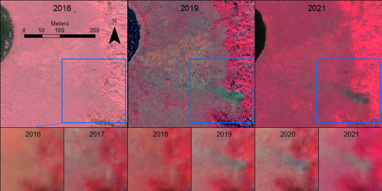
Formation of a new water source (footslope seep) near lake YUCH-004 in Yukon-Charley Rivers National Preserve, Alaska. In the upper row, WorldView-2 images (0.5-meter resolution) show the seep absent in 2016, present in 2019, and persisting in 2021. In the lower row, Planet images (3-meter resolution) from each year show the sudden appearance of the seep in 2019. Images are displayed in color-infrared. Water lilies in the lake on the left, visible as pink dots, disappeared between 2019 and 2021. The associated manuscript can be found here.
Disclaimer: Any use of trade, firm, or product names is for descriptive purposes only and does not imply endorsement by the U.S. Government.