
The Comprehensive Invasive Phragmites Management Planning project was completed to create an adaptive management plan for invasive phragmites control in the Saginaw Bay of Lake Huron, Michigan. Phragmites is a tall grass that chokes shorelines, limiting access for recreation activities, displacing fish and native vegetation, and creating a fire hazard. The FWS research team integrated local and regional knowledge, high-resolution maps from remote sensing data, and modeling of nitrogen (N) loading and hydrological connectivity to identify the best phragmites treatment and monitoring strategies. The outputs of this grant are products of multi-disciplinary integrative efforts between Michigan Technological University, University of Michigan, Michigan State University, Texas A&M, University of Northern Iowa, U.S. Fish & Wildlife Service, Michigan Department of Natural Resources, and the Saginaw Bay Cooperative Invasive Species Management Area.
Remotely sensed data informed this project, including a review of historical (1938 to present) aerial imagery of four sites to determine pre-invasion ecosystem type (wetland, beach, open water, etc.). WorldView-2 (WV2) submeter satellite imagery is being used to map pre- and post-treatment conditions, allowing managers to quantify the effectiveness of various treatment, including herbicide and cutting/burning. For pre-treatment in August 2016, the entire coastal area of Saginaw Bay and the Saginaw River (including all treatment areas) were mapped at a minimum mapping unit of 0.5 acre using interpreted WV2 data (http://geodjango.mtri.org/coastal-wetlands/). Post-treatment maps for summer 2017 were incomplete due to cloudy conditions, and 2017 imagery was only available for one of the four treatment areas (see figure). Imagery from the summer of 2018 will be downloaded for the four sites. Peak growing season post-treatment imagery provides needed information on the distribution of phragmites killed, standing dead, mowed vegetation, as well as missed phragmites and regrowing vegetation. This detailed site-level information is important for adaptive management; such a bird’s eye view is particularly valuable for large areas that are impassable by foot and those requiring large amounts of staff time to complete.
http://mtri.org/Phragmiteswetlandmanagementandscience.html
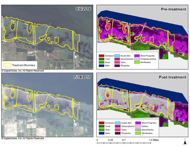
Pre- and post-treatment (2016 and 2017, respectively) invasive phragmites presence at the Hampton treatment area based on interpretation of WorldView-2 images.