
In the Great Lakes Basin, wetlands are considered to be the most vulnerable landscape feature subject to human actions and climate change. The wetlands are part of the water infrastructure and provide flood storage, storm surge protection, carbon storage, clean water, and unique fish and wildlife habitats. The public and wetland managers are asking for more frequent updates of wetland and adjacent habitat change. Monitoring wetlands seasonally is crucial to supporting protection and conservation.
Satellite and aerial views are an essential, cost-effective scientific management tool to track and observe wetlands and associated habitat changes over time. The ability to repeatedly map these wetlands and changes more frequently using submeter optical remote sensing systems in conjunction with radar remote sensing systems makes this project unique.
FWS scientists are leading a binational collaborative effort to map wetlands across the Great Lakes Basin and classify their associated habitats. The collaboration includes funding, processing and imagery support from the Great Lakes Restoration Initiative, the National Science Foundation, and the National Geospatial-intelligence Agency (respectively) to support remote sensing scientists at the University of Minnesota, Minnesota Department of Natural Resources, Michigan Tech University, SharedGeo, and the National Oceanic and Atmospheric Administration. Natural Resources Canada with Environment and Climate Change Canada are contributing their radar expertise to map wetland water extent and inundation over time using radar imagery that has been collected for the last two years over a dozen test pilot areas across the Great Lakes Basin. Multi-temporal vegetation elevation and ecosystem models have been completed at 2-meter resolution for the entire basin using existing DigitalGlobe satellite imagery to help aid in wetland and associated habitat classifications. Final products are expected to be delivered online to stakeholders and managers during fiscal year (FY) 2019. Access will be initially through the University of Minnesota servers and ultimately through the Federal government GeoPlatform website.
http://geodjango.mtri.org/coastal-wetlands/
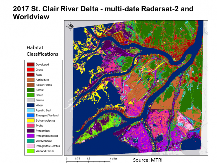
Habitat and wetland classifications for the St. Clair River Delta using MAXAR satellite imagery (DigitalGlobe and RADARSAT-2). Original imagery provided via National Geospatial-intelligence Agency NextView and NorthernView programs.