
The FWS Division of Migratory Bird Management is integrating remote sensing technology to enhance the safety, data quality, and cost-efficiency of migratory bird surveys that inform management decisions. Recent investments include 1) acquisition of data storage and high-performance computing resources and integration of these resources into the FWS’s information technology (IT) enterprise to support remote desktop processing and secure, centralized archive; 2) improvement and expansion of the Division’s direct georeferencing airborne remote sensing systems to include simultaneous acquisition of visible, near-infrared, and thermal imagery; and 3) partnerships with industry, other agencies, and the machine-learning/artificial intelligence research community to develop algorithms that automatically and rapidly identify and count birds from aerial imagery.
As an example, the Division, in cooperation with the U.S. Geological Survey (USGS) and a private contractor, surveyed sandhill cranes roosting overnight on the Platte River in March 2018 using a mid-wavelength thermal camera system (FLIR A8303sc). During spring migration, over a half-million cranes – a large proportion of the mid-continent population – stage in the Platte River Valley. This activity presents an opportunity to efficiently survey the population, and the Division has traditionally conducted a low-level aerial survey during daylight hours. Daytime dispersal of the cranes to feed have contributed to variable crane counts during the traditional survey. At night, however, the birds concentrate on the river to roost and stay put, making them easier to count. Furthermore, the nighttime thermal imagery has a larger field-of-view (FOV) than the daytime survey capturing more of the river channel in a single pass. Results of initial application of machine-learning algorithms implemented by the USGS to identify and count cranes from the thermal imagery have been highly encouraging.
Future applications will use side-by-side mounted thermal cameras to produce co-registered imagery with twice the FOV and enhance sampling efficiencies. With these advances, cost-efficient monitoring is within reach for this important population of cranes that was once rare but is now abundant enough to be locally hunted and harvested. This application of airborne remote sensing will improve personnel safety, provide reliable population and habitat-use data, and increase data utility by creating a long-term, georeferenced archive suitable for a variety of management and research applications.
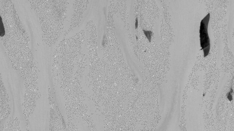
Nocturnal thermal image of roosting sandhill cranes collected on March 20, 2018, over the Platte River near Grand Island, Nebraska, at a flying height of 2,000 feet above ground level. Pixel resolution is 18 centimeters.