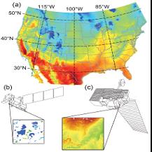
Surface freshwaters support rich biodiversity and provide many important ecosystem services. Documented warming of inland waters is widespread and can reduce water quality and negatively impact cold-water fish. While national-scale monitoring programs exist for the Nation’s rivers and streams (http://waterdata.usgs.gov/), lake temperature monitoring is comparatively rare. In order to evaluate climate impacts on lake temperatures from 1979 to 2011, mechanistic models for simulating temperatures in thousands of lakes were automatically parameterized using two primary sources of remote sensing data: 1) Advanced Spaceborne Thermal Emission and Reflection Radiometer (ASTER)-derived elevation data, which were used to estimate the degree of wind sheltering for lakes due to local canopy and topography effects, and 2) Landsat imagery, which were used to calculate water clarity . This effort resulted in publication of an ecological modelling paper titled "Simulating 2,368 temperate lakes reveals weak coherence in stratification phenology" in Ecological Modelling (J.S. Read and others, 2014, vol. 291, pp. 142-150, (doi:10.1016/j.ecolmodel.2014.07.029)). A methods paper, "Examining the utility of satellite-based wind sheltering estimates for lake hydrodynamic modeling," has been published in Remote Sensing of Environment (J. Van Den Hoek and others, 2015, vol. 156, pp. 551-560, (doi:10.1016/j.rse.2014.10.024)). These methods help quantify the diversity of lake responses to climate change across landscapes.
Satellite_land_data.pdf

Continental and global-scale data sources are critical inputs for parameterizing and driving thousands of one-dimensional lake models. a) The North American Land Data Assimilation System v2 (NLDAS-2) hourly gridded data for air temperature on June 1, 1979. b) Landsat imagery was used to estimate water clarity (clarity indices provided by lakesat.org). c) Topographic elevation data from the ASTER Global Digital Elevation Map v2 (GDEM2) were used to estimate wind sheltering heights surrounding individual lakes.

