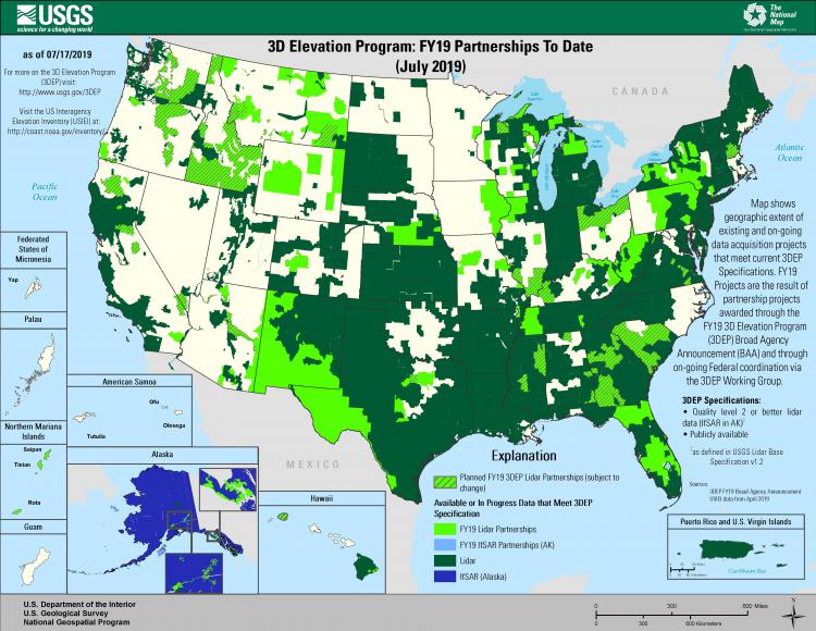
The goal of the 3D Elevation Program (3DEP) is to complete acquisition of nationwide lidar (Interferometric Synthetic Aperture Radar (IfSAR) in Alaska) in 8 years to provide the first-ever national baseline of consistent high-resolution elevation data—both bare earth and 3D point clouds—collected in a timeframe of less than a decade. If fully implemented within 8 years, 3DEP has the potential to provide more than $690 million annually in new benefits to government entities, the private sector, and citizens. This would result in a nearly 5:1 return on investment, informing critical decisions that are made across the Nation every day that depend on elevation data, ranging from immediate safety of life, property, and environment to long-term planning for infrastructure projects. The first full year of 3DEP production began in 2016, resulting in the target completion date for acquisition of 2023. 3DEP is managed by the USGS on behalf of a community of Federal, State, local, and other partners. Progress towards the completion goal has accelerated each year due in large part to partner investments. Today, over 60% of the Nation, including 100% of Alaska, has available or in-progress elevation data that meet 3DEP specifications for high accuracy and resolution. 3DEP is a “Call for Action” because no one entity can accomplish it independently. This coverage milestone is truly a community achievement, including partners that fund acquisition, the vibrant lidar industry and private sector mapping firms that collect the data, and a growing and innovative user base.

This map shows the geographic extent of available and in-progress data that meet 3DEP specifications as of July 2019.

