
Low-lying island environments, such as the Majuro Atoll in the Republic of the Marshall Islands, are particularly vulnerable to coastal flooding (inundation) whether the increased water levels are from episodic events (storm surge, wave run-up, king tides) or from chronic conditions (long-term sea-level rise). Land elevation is the primary environmental variable that determines exposure to inundation in coastal settings. Accordingly, detailed and accurate coastal elevation data are a critical input for assessments of inundation exposure and vulnerability. New remote sensing-derived high-resolution, high-accuracy elevation data, including comprehensive uncertainty information, are available for Majuro Atoll, and they represent a valuable resource for coastal hazard assessment. A quantitative assessment of inundation exposure for Majuro Atoll was conducted with these data, including rigorous accounting for the cumulative vertical uncertainty due to the geospatial data input to elevation models as well as data processing (datum transformations).
Areas subject to marine flooding (with a direct overland hydrologic connection to the ocean) and low-lying land (with no direct hydrologic flow path to the ocean) were mapped separately and characterized for three different inundation levels. These areas are mapped with three different approaches, including two that incorporate consideration of vertical uncertainty, so results can be expressed at a specific confidence level or probability. The inundation assessment shows the advantages of using a remote sensing-derived high-resolution, high-accuracy elevation model to produce spatially explicit hazard information. The results, which are a first for Majuro Atoll, are useful for characterizing and quantifying inundation exposure and related vulnerability of the atoll’s low-relief lands and their population, buildings, infrastructure, and natural resources. Such information is critical for climate change adaptation planning and mitigation.
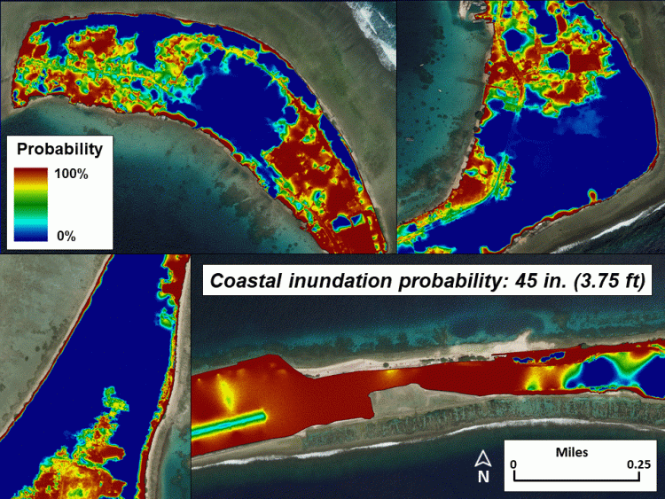
Inundation exposure assessment results for portions of Majuro Atoll in the Marshall Islands: Probability of inundation given an increase in ocean level of 45 inches above the current high tide line.