
A capacity to monitor land surface change across the conterminous U.S. was launched by the USGS in 2019 to meet increasing demands for timely and frequent integrated land cover and change information. Land Change Monitoring, Assessment, and Projection (LCMAP) is enabling nationwide tracking and characterization of annual changes in land cover, use, and condition and will produce in-depth assessments of current and historical land change. The goals of LCMAP include developing a capability to detect and characterize historical land change from data in the 1985–present Landsat archive, producing a suite of validated annual land change and land cover maps and area statistics, and ultimately modeling past and future change not covered by the satellite record.
Historical land surface change and land cover data are created from all available cloud- and shadow-free pixels in the Landsat Analysis Ready Data (ARD) archive using the Continuous Change Detection and Classification (CCDC) algorithm. CCDC is an automated time-series modeling approach that identifies different change events and characterizes a large variety of land cover types, uses, and conditions. The algorithm uses a threshold derived from all seven Landsat bands to capture various kinds of land cover change, which exhibit a wide range of spectral responses. When the difference between observed and predicted images exceeds a threshold three consecutive times, a pixel is identified as land surface change. After change is detected, land cover type is classified using a Random Forest Classifier (RFC). Using CCDC, Landsat ARD is consistently processed with high geometric fidelity and gridded to a common tiling scheme, providing high-quality data for time-series analysis. By using the historical depth of the Landsat archive, LCMAP reveals trajectories of land change from the mid-1980s to the present at 30-meter spatial resolution.
The LCMAP Version 1 product suite includes 10 annual historical land change and land cover map products. The initial release covers a 33-year period from 1985 to 2017 with more recent years to follow. Sample products are now available for a single tile over central California, and Version 1 national production is in progress. The CCDC approach in the current historical workflow needs a series of at least six high-quality (i.e., cloud- and shadow-free) Landsat ARD observations to support robust change detection with low lead times. Methods for faster change detection where existing models are compared to the most recent ARD observations to determine where conditions are changing rapidly are providing improved sensitivity for change detection. The USGS is defining requirements for an automated system that can alert relevant land managers to important emerging changes in cover or condition in their jurisdictions to support development of a monitoring capacity where change can be detected with a 3- to 6-month latency.
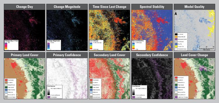
Version 1 LCMAP sample data for Landsat Analysis Ready Data tile (h03v10) includes a suite of 10 integrated annual map products. The top row shows five land change datasets and the bottom row shows five land cover datasets depicted for 2016. More information and data access can be found at https://www.usgs.gov/land-resources/eros/lcmap/lcmap-sample-products.