Groundwater research is often hindered by the scarcity of information about the subsurface, leading to uncertainty in groundwater model predictions and resource management decisions. Borehole and well data, where available, represent invaluable but spatially limited windows into the hydrogeologic conditions at depth, and it can be difficult to assess how conditions change between these points. To fill in the gaps, the USGS has been using airborne electromagnetic (AEM) methods as part of a number of groundwater-resource and related studies. AEM data can be used to develop spatially comprehensive and regionally extensive maps of electrical resistivity in three dimensions that, in turn, can be related to key physical properties such as lithology, water content, water salinity, and frozen/unfrozen conditions. While analogous to ground-based geophysical methods that are commonly employed for groundwater studies, AEM surveys provide high-resolution information about the subsurface over far larger study areas, leading to new insights into groundwater availability, geologic controls on groundwater movement and occurrence, salinity distributions, geothermal processes, and cryosphere studies at regional scales.
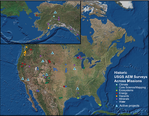
AEM research has contributed to a number of research projects at the USGS. In the San Joaquin Valley of California (blue triangle (a) on the map below), AEM surveys are being used to map the 3D extent of relatively fresh groundwater in the vicinity of oil and gas fields as part of a new regional groundwater quality monitoring program in cooperation with the State of California Water Resources Control Board. In the northern Mojave Desert (b), AEM data are being used to inform the design of groundwater flow models in geologically complex and otherwise data-sparse intermountain basins. These models are an important component of ongoing groundwater availability and sustainability assessments for the Fort Irwin Army National Training Center. In Yellowstone National Park (c), AEM data are providing an unprecedented new view into the shallow plumbing of geysers and other geothermal features throughout the park. Near Crested Butte, Colorado (d), an AEM survey of the East River watershed is being planned that will contribute to geochemical, ecological, and groundwater modeling studies evaluating nutrient cycling and groundwater sustainability in high-elevation watersheds. In the East Poplar Oil Field in northeastern Montana (e), time-lapse AEM surveys are being used to evaluate the movement of shallow brine contamination that impacts local drinking and irrigation water supplies for the Ft. Peck Indian Reservation. In Cedar Rapids, Iowa (f), AEM data are being used to inform groundwater management strategies for municipal supplies. In the Mississippi Alluvial Plain (g), AEM surveys are being developed to map salinity and floodplain aquifer geometry in support of groundwater modeling efforts that are part of a regional assessment of groundwater resources and sustainable resource management. In Alaska (h), AEM data are providing detailed new insights into the distribution of permafrost and its impact on surface-water and groundwater systems within the lake-rich Yukon Flats ecoregion.

Map showing the locations of USGS-supported airborne electromagnetic (AEM) surveys across various USGS programs. Triangles indicate the active groundwater-related research projects highlighted in this summary.

