
Barrier islands provide numerous invaluable ecosystem services, including storm protection and erosion control for the mainland, habitat for fish and wildlife, salinity regulation in estuaries, carbon sequestration in marsh, recreation, and tourism. These islands are dynamic environments due to their position at the land-sea interface. Storms, wave energy, tides, currents, and relative sea-level rise are powerful forces that shape barrier island geomorphology and habitats. To better inform both present and future management decisions, coastal resource managers require products developed from remote sensing, such as habitat maps, for insights into how these dynamic islands are changing over time. The Barrier Island Comprehensive Monitoring (BICM) program was developed by Louisiana’s Coastal Protection and Restoration Authority (CPRA) and is implemented as a component of the System-Wide Assessment and Monitoring Program (SWAMP). The BICM program uses both historical and contemporary data collections to assess and monitor changes in the aerial and subaqueous extent of islands, habitat types, sediment texture and geotechnical properties, environmental processes, and vegetation composition.
The USGS Wetland and Aquatic Research Center provides geospatial support to the BICM program for mapping barrier island habitats and assessing habitat change over time. For this effort, habitat maps are being generated from high-resolution orthophotography and lidar data using object-based analyses in the Trimble eCognition 9.3 for 2008 and 2015/2016 for numerous coastal reaches in Louisiana. This software allows for a variety of data, such as aerial imagery and elevation data, to be integrated into a habitat mapping process. The BICM program has developed two habitat classification schemes, which include a detailed 15-class and a general 8-class habitat scheme. The detailed scheme was developed specifically for this habitat mapping effort and builds off the general scheme used in previous BICM habitat mapping efforts. The additional classes developed in the detailed scheme are primarily used to further delineate various dune habitats, separate marsh and mangrove, and distinguish between beach and unvegetated barrier flat habitats. Spatial change analyses will be conducted between previously developed BICM habitat maps from 2005 and the 2015/16 habitat maps produced through this effort. The habitat maps and change assessment products produced through this project are being published as regional products as USGS data releases.
https://www.sciencebase.gov/catalog/item/5a32ebe1e4b08e6a89d886b4
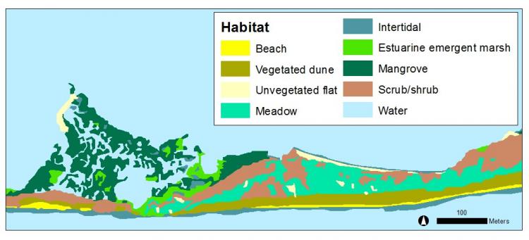
Habitat map using the BICM detailed classification scheme for 2016 for a portion of Trinity Island, Louisiana.