
To help assess the uses and value of Landsat imagery, social scientists at the USGS Social and Economic Analysis (SEA) Branch of the Fort Collins Science Center in Colorado are leading a long-term study, which includes surveys and case studies of Landsat imagery users. A series of surveys provides longitudinal data on how the users and uses of the imagery are changing over time in response to changes in the provision of the imagery, and allows analysts to explore the value of the imagery. Multiple case studies focusing on the use and benefits of Landsat imagery in water, agriculture, forestry, and private sector technological applications have been completed. These case studies provide context and depth, which complement the more quantitative survey data. In 2017, a report containing multiple case studies on the use of Landsat in agriculture was published (https://pubs.er.usgs.gov/publication/ofr20171034). A Landsat user survey was also developed in 2018 to assess current and future requirements that will be used to inform the development of future Landsat satellites.
https://www.fort.usgs.gov/landsat-study
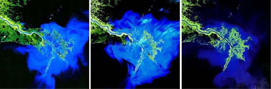
Example case study using Landsat archive. Landsat images above document change in the Mississippi delta, USA, over a 30-year time span (L-R: 1973, 1989, 2003). Source: http://landsat.usgs.gov/gallery.php.