
Scientists have effectively monitored vegetation dynamics using remotely sensed time-series vegetation index (VI) data for several decades. Drought monitoring has been a common application of VI data; perhaps the most used VI data, Normalized Difference Vegetation Index (NDVI), serves as an input for drought-stress models such as the Vegetation Drought Response Index (VegDRI). NDVI composites from the expedited Moderate Resolution Imaging Spectroradiometer (eMODIS) satellite platform were a main input for the VegDRI model, but as the MODIS satellite platforms approach the end of their missions, replacement satellite data were needed to continue developing VegDRI. The USGS Earth Resources Observation and Science (EROS) Center developed a parallel temporal version of eMODIS by utilizing data from the Visible Infrared Imaging Radiometer Suite (VIIRS) platform. The expedited VIIRS (eVIIRS) product consists of 7-day rolling NDVI composites at 375-meter and 1-kilometer spatial resolution.
The EROS researchers developed a simple, robust algorithm to transform eVIIRS NDVI to eMODIS-like NDVI. (The transformed eVIIRS NDVI is referred to as eVIIRS’.) They then designed a research study to test eVIIRS’ NDVI for use in the VegDRI drought monitoring production system. The geometric mean regression (GMR) transformation algorithm was developed from 3 years (2016–2018) of eVIIRS 375 and eMODIS 250-meter NDVI data. After transforming 2020 eVIIRS to eVIIRS’ using the GMR transformation algorithm, the NDVI values showed improved results with the mean bias error decreasing by more than 62% and the root mean square error (RMSE) decreasing by more than 17%. The VegDRI map using eVIIRS’ data showed similar results compared to the VegDRI map using eMODIS data. Also, when eMODIS was replaced with eVIIRS’ in the VegDRI model, the relative RMSE equaled 18%, which indicated the replacement of eMODIS with eVIIRS’ was a good fit for VegDRI.
The approach used to modify data inputs into the VegDRI model by using eVIIRS’ NDVI in place of eMODIS NDVI data demonstrates the ease of use of the GMR transformation for data continuity and longevity. The transformation may allow eVIIRS to continue the more than 20-year time series of eMODIS NDVI data.
https://doi.org/10.3390/rs13061210
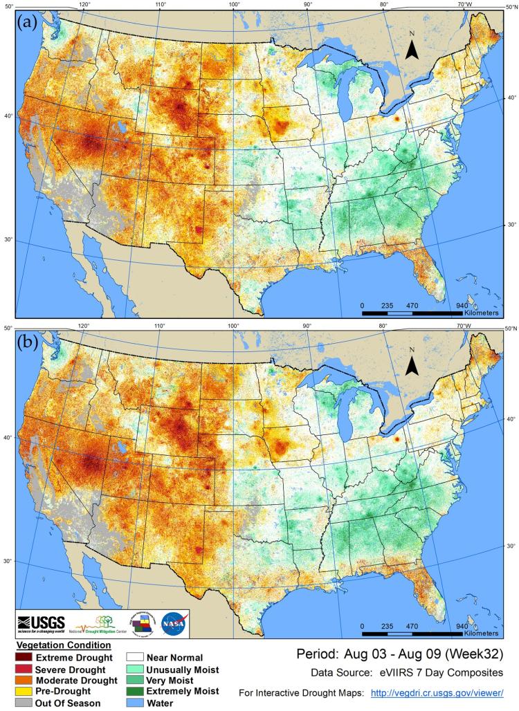
Transforming eVIIRS NDVI data into eMODIS-like NDVI data. The comparison of Vegetation Drought Response Index (VegDRI) results from (a) expedited Moderate Resolution Imaging Spectroradiometer (eMODIS) and (b) transformed expedited Visible Infrared Imaging Radiometer Suite (eVIIRS’), where eVIIRS’ = 0.9887 × eVIIRS − 0.0398, for week 32 in 2020 (August 3, 2020 to August 9, 2020).