
Shrublands in southern California have seen sweeping changes in vegetation composition and structure due to fire and drought. Invasion of nonnative grasses after repeated fire or drought events can inhibit shrub recovery and lead to vegetation type conversion to nonnative grassland. In San Diego County, chaparral and coastal sage scrub vegetation communities are at risk, with some areas experiencing large declines in shrub cover. Past vegetation monitoring has focused on field-based methods, which provide great insight on plant composition and small-scale changes but are limited in spatial scope. Remote sensing can be used to identify large-scale changes across more expansive areas. When used in combination with field methods, remote sensing data also allow researchers and managers to prioritize field surveys.
Past studies using remote sensing focused on imagery only. In 2014 and 2015, high-resolution terrestrial lidar was collected for San Diego County. This project incorporated new, topographic information from lidar to refine imagery-based models. A Digital Elevation Model (DEM) and Digital Surface Model (DSM) were created from the lidar point cloud at 1-meter resolution. Using these products, height above the natural surface was calculated (Normalized Digital Surface Model: nDSM) and clipped to open space areas.
Vegetation form was estimated using the height above the natural surface, with grass estimated as less than 0.5 m, shrubs at 0.5–2 m, and trees at greater than 2 m. Normalized Difference Vegetation Index (NDVI) was calculated from a 2014 National Agriculture Imagery Program (NAIP) image (also 1-meter resolution, 4-band). Due to an extreme drought in 2014, lidar was essential to understanding the extent of dormant shrubs that dropped leaves even in the growing season. Percent cover of each vegetation form was calculated with an NDVI cutoff used to measure the percent active and the percent dormant or dead.
The natural surface was verified using established National Geodetic Survey benchmarks and exceeded 98% accuracy. Vegetation structure was validated using visual assessments of high-resolution aerial imagery to verify the vegetation form and greenness. Vegetation form and health (as indicated by NDVI) had an accuracy of 82%.
Future analysis may include multiple years of NAIP imagery to understand how shrublands are responding to drought and fire. Landsat imagery may also be used to understand the long-term changes from the 1990s and into the future. Statistical analyses may provide insight into patterns of vegetation change in response to climate and fire processes and assist in prioritizing areas for management and assessing effectiveness of management actions.
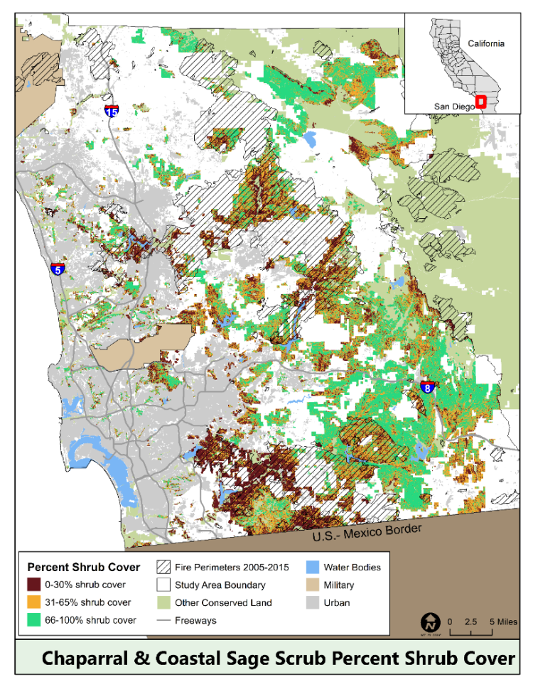
Map of shrub cover in San Diego County, developed using remotely sensed imagery.