
The USGS Land Change, Monitoring, Assessment, and Projection (LCMAP) project recently released an updated suite of land surface change science products based on the Landsat archive. The most recent LCMAP science collection includes 10 annual land change and land cover map products for the time period 1985–2019 for the conterminous United States. The integrated products are the basis for applications and assessments designed to promote an understanding of the basic drivers of change, identify potential consequences of change on human and natural systems, and offer greater insight into the impacts and feedbacks of climate change. LCMAP leverages the USGS Landsat Program’s decades of land imaging, future Landsat acquisitions, time-series modeling, and USGS Earth Resources Observation and Science (EROS) Center scientific expertise. The annual land cover, and its change, through 2018 was validated using published reference data, providing quantitative measures of product accuracy. An update to the product suite through calendar year 2020 was released in late 2021.
LCMAP supports and engages with the user community through various forms of communication including instructional videos that describe the land change products, workflows to expedite common data processing and analysis routines, and stakeholder workshops. The EROS Center provides geospatial products through a number of public-facing websites including USGS’s EarthExplorer, LCMAP’s Web Viewer, and website download access for each annual product compiled for the entire conterminous United States. The LCMAP team also established a collaboration with researchers from the National Center for Atmospheric Research. This effort focuses on developing methodology to improve and enhance tools that enable the management community to visualize, summarize, and incorporate land surface change information through time.
Having access to an annual time series of land cover and surface change enables assessments of land change to improve understanding of their causes and consequences. Several published assessments incorporated annual LCMAP land surface change products. The publications range from new insights on how urban heat islands affect surrounding rural land cover to how droughts with hotter temperatures impact the extent of tree cover within an endemic California forest type. The latter research analyzed LCMAP land change data, geospatial climatic data, and wildfire mapping to reach their conclusions. Other geographic and topical assessments are in various stages of the publication process.
https://www.usgs.gov/core-science-systems/eros/lcmap
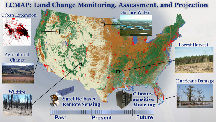
LCMAP science products support a variety of applications and assessments.