
Human water use that alters river flow can shape ecology and biodiversity in many riverine and associated environments. Population viability is often linked to the timing and extent of floodplain and wetland inundation, and disruptions to historical flow regimes can have major impacts on species that have difficulty adapting to altered environments. Explicit information on the extent and timing of inundations in riverine and wetland habitats, particularly as they may have varied over the span of decades, is rare. However, the multi-decade record of intra-annual surface inundation provided by the USGS Landsat Science Product DSWE (Dynamic Surface Water Extent) provides a potential data source to fill this information need.
The Oregon spotted frog (Rana pretiosa), which is endemic to northwestern North America, has experienced population losses associated with hydrological changes. In the species’ core extant range in the Upper Deschutes and Little Deschutes subbasins in Oregon, dam operations have altered historical flow regimes. Ongoing field-based studies of R. pretiosa seasonal habitat, including wetted extent, along with published data on drought, reservoir storage, and hydrology (Deschutes River streamflow), were combined with DSWE area of inundation estimates and compared against a variety of R. pretiosa population metrics. This suite of data allowed for long-term exploration of relationships among core site inundation, R. pretiosa population viability, and streamflow regulation. Seasonal patterns of abundance and survival varied among sites and were linked to relationships between streamflow and habitat that result from various mechanisms and levels of connectivity among streams and wetlands. This study highlighted the potential of long-term, systematically produced data like DSWE for use in science and resource management by scientists and managers who have expertise in fields other than remote sensing.
https://doi.org/10.1002/ecs2.3634
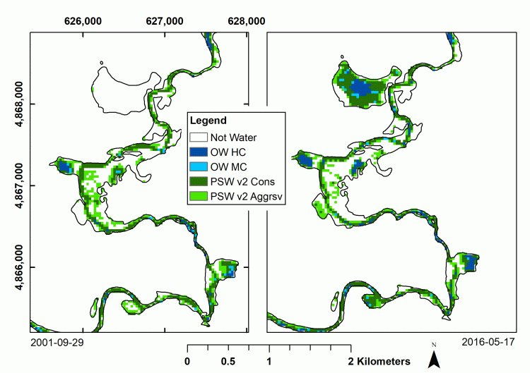
USGS Dynamic Surface Water Extent (DSWE) data for two dates show the variable nature of wetland inundation among core sites for a threatened species and allow improved analyses of streamflow management impacts on population viability. Legend: OW HC (Open water, High Confidence); OW MC (Open water, Moderate Confidence); PSW v2 Cons (Partial Surface Water at Landsat resolution [30m], conservative); PSW v2 Aggrsv (Partial Surface Water at Landsat resolution [30m], aggressive). Figure from Jones 2019 (https://doi.org/10.3390/rs11040374).