
The USGS Geosciences and Environmental Change Science Center and the Earth Resources Observation and Science (EROS) Center have led the development, validation, and production of the Landsat Burned Area products. The products identify burned areas in Landsat images, which have a spatial resolution of 30 m and a temporal resolution of 16 days or more, depending on cloud cover. Fires are frequently unreported; consequently, existing fire databases are often incomplete. Furthermore, these databases often have location errors and records may be duplicated. The Landsat Burned Area products provide new and unique information about spatial and temporal patterns of fire occurrence that existing fire databases may lack, especially in areas where fire information can be incomplete, such as the Great Plains and in the western and southeastern United States.
The Landsat Burned Area products have been produced for 1984–2019 for the conterminous United States (CONUS). Scene-level products are available through the USGS EarthExplorer and annual composites are available through the USGS ScienceBase Catalog. Products for 2020 will be available soon.
https://www.usgs.gov/core-science-systems/nli/landsat/landsat-burned-area
https://doi.org/10.1016/j.rse.2020.111801
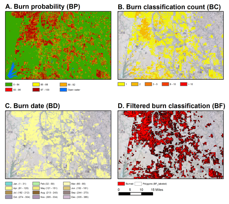
Examples of the Landsat Burned Area annual composite products.