
California’s oceanic waters provide habitat for numerous migratory, resident, and breeding species of seabirds and marine mammals. Recent technological advances have made offshore wind energy infrastructure development a possibility for the deep waters off the U.S. West Coast. Multiple wind energy projects have been proposed for the region including two wind energy areas in deep offshore waters off central and northern California.
Marine birds and mammals are vulnerable to risks associated with wind energy development. The U.S. Geological Survey (USGS) Western Ecological Research Center (WERC) Seabird Team currently is re-evaluating and updating its report quantifying the vulnerability of seabirds to wind energy infrastructure. With support from the Bureau of Ocean Energy Management (BOEM), the Seabird Team also recently completed extensive seasonal aerial bird and mammal surveys to provide updated information about animal distributions and abundance at sea. One goal of the forthcoming results will be to help managers identify areas at sea where potential wildlife interactions with offshore wind energy infrastructure may occur.
During 2018-2021, USGS WERC scientists conducted digital aerial surveys from a small airplane from Point Piedras Blancas on the central California coast to the United States-Mexico border. Survey aircraft are outfitted with digital cameras linked to computers. The USGS captured >800,000 high-resolution digital photographs during spring, fall, and winter seasons.
Using rapidly developing machine learning techniques, the USGS WERC team worked with a partner to develop new methods to automate the detection of seabirds and marine mammals from imagery. Use of ML to extract quantitative information from images will allow USGS to share contemporary data about species composition, distribution, abundance, habitat associations, and seasonal variation. Maps of these data can be used to inform the planning process for offshore wind development. About one quarter of the images contained birds and mammals, but most only featured the surface of the ocean. After developing a robust detection algorithm that included 8 object classifications, the team began the arduous task of identifying species using an online feature annotation tool developed in part by the USGS computer vision team at UMESC. Ultimately, the reclassified final data set will offer the most substantial and unique image library available for training more accurate ML models that can be used to streamline future survey efforts off the Pacific West Coast.
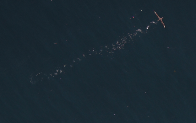
Zoomed aerial image of a Black-footed Albatross (Phoebastria nigripes) taking off from the water. Credit: Laney White (U.S. Geological Survey).
Disclaimer: Any use of trade, firm, or product names is for descriptive purposes only and does not imply endorsement by the U.S. Government.