
The U.S. Geological Survey (USGS) is working with the San Carlos Apache Tribe to map current and historical riparian areas on the San Carlos Apache Reservation to identify regions vulnerable to wildfire and to target restoration efforts. This long-term collaboration is focused on providing information and training to Tribal land managers and employees for enhancing restoration activities to improve climate resilience. The USGS is using satellite imagery and watershed modelling to help the Tribe’s natural resource managers prioritize areas for firebreak and water detention installations along river and tributary streams in priority watersheds. Results have demonstrated that such nature-based solutions can boost resilience to wildfire by increasing water availability and reducing water stress, while preventing post-fire flooding and erosion. The Forest Resources, Environmental Protection, and Range departments within the San Carlos Apache Tribe are engaged in preventative thinning of vegetation, invasive plant removal, native plant restoration, and resource-benefit burns, which the USGS has also shown to reduce wildfire intensity and enhance ecosystem services. The U.S. Forest Service is using this guidance to consider expanding similar nature-based practices to Apache Ancestral Lands in collaboration with the Bureau of Indian Affairs. The associated manuscript is available here and the data are available here.
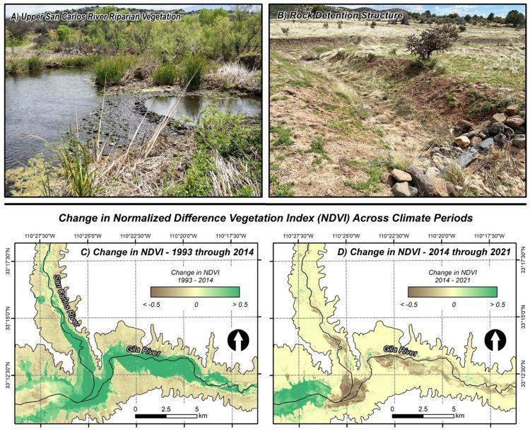
Images of riparian area and restoration on the San Carlos Apache Reservation, including (A) riparian vegetation along the Upper San Carlos River and (B) rock detention structures on grassland uplands. The two lower maps show change in Normalized Difference Vegetation Index (NDVI) across two separate climate periods at the confluence of the San Carlos River and the Gila River, including (C) 1993 through 2014, where vegetation filled in areas that had previously been flooded, and D) 2014 through 2021, where recent wildfires have resulted in the loss of vegetation. Photo credit for (A) and (B): Laura Norman (U.S. Geological Survey). The associated manuscript is available here.
Disclaimer: Any use of trade, firm, or product names is for descriptive purposes only and does not imply endorsement by the U.S. Government.