
Coastal wetlands and estuaries are critical ecosystems that serve as the bridge between land and sea, provide habitat for numerous species of fish and wildlife, and offer protection from storms and waves for inland communities. When these environments evolve naturally, they can adapt to rising sea levels by retreating landward, and fish and wildlife follow suit. However, when obstacles such as coastal development, agriculture, and infrastructure prevent these migrations from occurring, wetlands can flood and degrade along with the services they provide.
Scientists at the U.S. Geological Survey St. Petersburg Coastal and Marine Science Center have developed new methods for mapping shorelines using high-resolution satellite data. The satellite data are combined with field methods, historical maps, aerial imagery, and lidar to monitor shoreline change in several critical estuarine systems across the United States. Areas of interest include the populated coastline of New Jersey, the protective barrier islands of Louisiana, and protected Federal lands along the Mississippi and Alabama coasts. Remote sensing data allow scientists to calculate which estuarine shorelines are changing most rapidly, which are able to adapt to changing environmental conditions and keep pace with rising sea levels, and which may be most vulnerable to the effects of climate change. The team developed a series of geonarratives to allow users to visualize these changes in an interactive and meaningful way. This information is shared with partners, resource managers, and the public and can be used to inform decisions on restoration and adaptation planning.
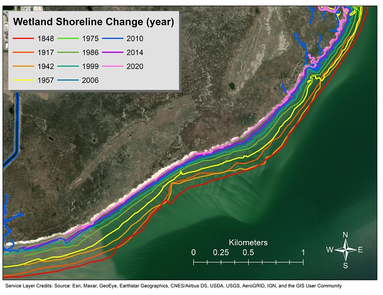
Digitally mapped shoreline position from 1848 to 2020 for a portion of the Grand Bay National Estuarine Research Reserve in Mississippi. The map shows how shoreline data provide evidence of coastal wetland erosion over time. More information on the project is available here.
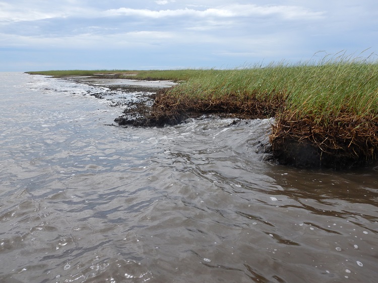
An eroded marsh shoreline in Point Aux Chenes, Louisiana. Degraded shorelines are a common sight in estuarine ecosystems. U.S. Geological Survey (USGS) scientists use remote sensing data, such as high-resolution satellite imagery, to study how these shorelines are changing over time in response to sea-level rise. Photo credit: Alisha Ellis (USGS).
Disclaimer: Any use of trade, firm, or product names is for descriptive purposes only and does not imply endorsement by the U.S. Government