
The High Plains Aquifer (HPA) is the primary water source for irrigated agriculture in the Great Plains of the United States. However, water levels in many locations of the aquifer have declined steadily over the past several decades because the rate of water withdrawals exceeds the rate of aquifer recharge. The decline of the groundwater table has been a serious concern to farmers and local governments in the HPA region as crop production is heavily dependent on the groundwater source. Evaluation of historical water use and the driving factors in the region are important for understanding the relationships between water resources (such as rainfall, streamflow, and groundwater) and irrigation practices. This study evaluated the temporal trends of historical (1985–2015) agricultural water use across the HPA region using the U.S. Geological Survey’s National Water-Use Science Project dataset. It also evaluated the trends and variances of the hydroclimatic factors from 1985 to 2020 using a suite of geospatial and remotely sensed datasets including precipitation, air temperature, reference evapotranspiration, and runoff groundwater level, as well as terrestrial water storage (TWS) from the Gravity Recovery and Climate Experiment (GRACE) satellite mission. The results showed that the total water withdrawals in the HPA region increased from 21.3 cubic kilometer per year (km3/year) in 1985 to 24.8 km3/year in 2000, and then decreased to 18.2 km3/year in 2015. The total irrigated cropland area in the region increased slowly from 71,928 square kilometers (km2) in 1985 to 78,464 km2 in 2015. Over the same period, the area of sprinkler systems increased by 118%, while the area of gravity systems decreased by 72%. The precipitation, air temperature, evapotranspiration, and runoff time series showed wetting trends in most of the northern HPA region, but drying and warming trends in the south. The groundwater level time series indicated flat trends in the north, but declining trends in the central and southern subregion. Researchers also observed positive trends (2002–2020) in TWS in the northern aquifer and negative trends in the central and south. The trends in irrigation water withdrawals and irrigation area across the HPA appear to be controlled by the advancement of irrigation systems and technologies and the management of sustainable water use but are also affected by dynamic changes in the hydroclimatic conditions. The study on the dynamics of water use and climatic variability will provide useful information for management of irrigation agriculture and water resources in the Great Plains.
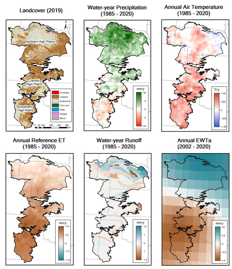
Land cover types and temporal trends in hydroclimatic variables across the High Plains Aquifer region. Data source: Land cover –USGS Land Change Monitoring, Assessment, and Projection (LCMAP); Precipitation and air temperature – PRISM Climate Group; Reference evapotranspiration (ET) – gridMET; Runoff – USGS WaterWatch; Equivalent water thickness anomaly (EWTa) – Gravity Recovery and Climate Experiment (GRACE) satellite. The associated manuscript is available here.
Disclaimer: Any use of trade, firm, or product names is for descriptive purposes only and does not imply endorsement by the U.S. Government.