
Don’t stare—take moving pictures, they will last longer. The U.S. Geological Survey (USGS) is developing a workflow for estimating the speed of the water flowing in a river using imagery acquired from a moving aircraft. Previous studies have, in fact, stared, by mounting cameras on quasi-stationary platforms (drone, helicopter, satellite) that hover in place while acquiring image sequences over rivers. River speed is then estimated using a technique called particle image velocimetry (PIV). This method operates on an image time series and uses a cross-correlation algorithm to measure the movement of features on the water surface from one image to the next. The feature displacement is combined with the time interval between the images to calculate river speed. Knowing river speed is important for estimating flow rates, characterizing contaminant transport, and various ecological applications.
USGS is collaborating with the U.S. Fish and Wildlife Service (FWS) to assess the feasibility of performing PIV using images obtained from an airplane flying over a river. This mode of acquisition would collect data more efficiently and allow river speed to be mapped more quickly over longer distances. Airplanes also have the important advantage of being more widely available and less expensive to operate than helicopters. However, operating an airplane is not without challenges. One difficulty is that the camera system must capture images rapidly enough to ensure that the overlap between successive image frames is sufficient to acquire multiple images of the same area on the river surface and track the movement of features. In addition, the spatial locations of all the images must be determined precisely to avoid erroneous estimates of river speed.
USGS and FWS tested two imaging systems operated from a fixed wing aircraft. Flight plans were developed for three different flying heights (600, 902, and 1,204 meters above ground level) to examine how image spatial resolution influences the accuracy of speed estimates. All images were precisely triggered and geotagged using GPS and positions were refined using photogrammetry techniques. Field data were collected along the Tanana River, Alaska, study reach from a boat with an acoustic Doppler current profiler (ADCP), which is a more traditional, field-based approach to measuring the speed and flow of a river. Results indicate that this remote sensing approach was successful, producing river speed estimates that are comparable with the ADCP.
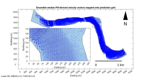
Velocity field for a portion of the Tanana River in Alaska derived from images acquired by an airplane flying 1,204 meters above the channel using a customized Particle Image Velocimetry (PIV)-based workflow. The length of each vector represents the speed of the river surface, and its orientation indicates the direction of flow. The associated manuscript is available here.
Disclaimer: Any use of trade, firm, or product names is for descriptive purposes only and does not imply endorsement by the U.S. Government.