
The Nation’s coastlines are highly dynamic ecosystems that can change drastically in response to storms, high water levels, and sea-level rise. These changes can put habitats, lives, and infrastructure at risk. The U.S. Geological Survey (USGS) has the expertise and capabilities to measure these coastlines and predict where and when coastal change may occur, but updated coastal elevation data are needed to keep these forecasts as accurate as possible.
Scientists at the USGS St. Petersburg Coastal and Marine Science Center (SPCMSC) use lidar-derived topobathymetric data to characterize the shape of the coastline, identify coastal features such as dunes, and update inputs to coastal change forecasting models. Remote sensing data like lidar allow for the collection of topographic and bathymetric data over larger scales compared to previous field collection techniques that required extensive human hours and equipment to gather only a small subset of data for a given area.
Recently, the SPCMSC team developed a database with updated topobathymetric data for sandy coastlines along the U.S. Atlantic and Gulf of Mexico coasts—areas that are subject to coastal hazards like extreme storms. This high-resolution, large spatial dataset helps advance the science and understanding of coastal evolution across many different disciplines such as geology, oceanography, engineering, ecology, and coastal management. By using the most recently collected remotely sensed lidar measurements, scientists ensure that models are developed with the best available coastal morphology data to accurately forecast change along the coast. Forecasts include where and when coastal change may occur, such as erosion (when sand is taken off and away from the coast), overwash (when water pushes sand inland past the dunes), and inundation (when water reaches over the dunes and remains there). These predictions are critical for coastal managers to determine risk to coastal homes, lives, and infrastructure, and can be used by communities to better prepare for, adapt to, and mitigate coastal hazards.
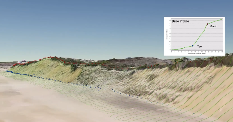
U.S. Geological Survey (USGS) scientists identify and measure coastal features from remotely sensed data such as lidar. Understanding the position and height of coastal features such as dunes and bluffs allows the USGS to predict impacts to the beach caused by storms.
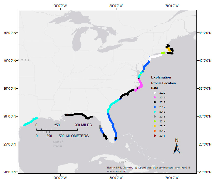
This subset of the National dataset shows cross-shore profile locations across the Atlantic and the Gulf coasts of the United States. Each dot indicates the location and year of the most recent lidar acquisition.
Disclaimer: Any use of trade, firm, or product names is for descriptive purposes only and does not imply endorsement by the U.S. Government.