
Irregularly flooded wetlands supply important ecosystem services, such as providing habitat for fish and wildlife, enhancing water quality, ameliorating flooding impacts, supporting coastal food webs, and protecting coastlines from erosion. Mapping irregularly flooded wetlands is a daunting challenge given their expansive coverage and dynamic nature. Furthermore, coastal wetlands are expected to change drastically over the coming century due to accelerated sea-level rise and changes in the frequency and intensity of extreme storms. Consequently, coastal managers need baseline information on the current spatial distribution of wetlands along with efficient repeatable methods for observing change in these important and dynamic environments.
Researchers from the U.S. Geological Survey (USGS) Wetland and Aquatic Research Center and Mississippi State University have jointly produced geospatial datasets of irregularly flooded wetland probability and high marsh and salt panne/flat habitats across the northern Gulf of Mexico coast, from Texas to Florida. The data release produced through this effort also includes a map from Lake Pontchartrain, Louisiana, to the Florida Big Bend delineating the coverage of irregularly flooded wetlands dominated by Juncus roemerianus (Black needlerush); a supplemental map with a second high marsh class in Texas dominated by succulents and Distichlis spicata (saltgrass); a project-specific field reference dataset; and spatial metadata showing the elevation data used to create these products. These products are the first regional map of elevation-based irregularly flooded wetland probability map and high marsh and salt panne/flat map along the northern Gulf of Mexico coast and provide a baseline condition to which future changes can be compared.
This effort is the result of research funded by the National Oceanic and Atmospheric Administration's RESTORE Science Program to Mississippi State University and the USGS. Many other agencies assisted with the development of these products, including the U.S. Fish and Wildlife Service, Tall Timbers Research Station, Texas Tech University, Louisiana State University, Grand Bay National Estuarine Research Reserve, Weeks Bay National Estuarine Research Reserve, Embry-Riddle Aeronautical University, and the Forbes Biological Station. The maps are publicly available and can be viewed via ArcGIS Online, and related waterbird conservation activities and news can be read about in a project blog.
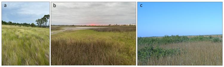
Examples of irregularly flooded wetlands along the Gulf of Mexico. a) Spartina patens (saltmeadow cordgrass) marsh. b) Marsh with Juncus roemerianus (black needlerush), Distichlis spicata (saltgrass), and a salt panne in the background. c) Avicennia germinans (black mangrove) and Spartina patens marsh in coastal Louisiana. Photo credit: (a, b) Heather Levy (Tall Timbers Research Station), (c) Nicholas Enwright (U.S. Geological Survey).
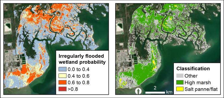
Examples of the two map products. The map on the left shows the irregularly flooded wetland probability output and the map on the right shows the high marsh and salt panne/flat map. All maps are available here.
Disclaimer: Any use of trade, firm, or product names is for descriptive purposes only and does not imply endorsement by the U.S. Government.