
The USGS Land Change, Monitoring, Assessments, and Projections (LCMAP) project was instituted to monitor and assess land use and land cover change through time, promote understanding of the causes and consequences of land change, and offer insight into the interactions between land change and climate change. LCMAP utilizes all available observations produced by the U.S. Geological Survey (USGS) Landsat Program to monitor change and to produce annual land change products. In 2022, LCMAP released updated products covering a 37-year record from 1985 to 2021. The LCMAP product suite includes a suite of annual land change and land cover products. The annual land cover from 1985 to 2017 was formally validated using a reference dataset produced by manual image interpretation. Collection of updated reference data for validation for 2018 to 2021 was launched in 2022.
LCMAP has recently developed modifications for the change detection methodology used to produce land change maps. The modified method (Band-First Probability, or CCD-BFP) calculates the statistical test for change differently to reduce the effect of differences in the number of available observations on change detection. Since the availability of remote sensing observations varies across space and time, it is useful to have a methodology that is consistent, especially given increases of data availability with additional new satellite data.
Information from the LCMAP product suite enables unique applications and assessments of land change. For example, LCMAP change information was transformed to indicate the duration of tree cover regrowth after disturbance across conterminous United States forested regions. The average tree regrowth period was estimated and validated. Trees in the southeastern U.S. took five years to recover on average, which is faster than other regions in the U.S. The Pacific Northwest coastal region was another main area of tree regrowth where trees often took multiple decades to recover.
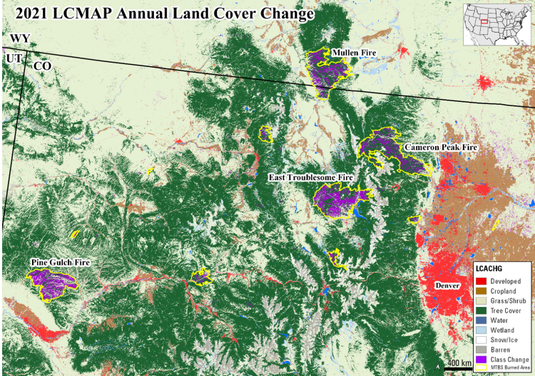
Recent fire-related land cover change in Colorado, as detected in the LCMAP Collection 1.3 update.
Disclaimer: Any use of trade, firm, or product names is for descriptive purposes only and does not imply endorsement by the U.S. Government.