
Vegetation provides vital ecological, hydrological, agricultural, and recreational ecosystem goods and services. Rangeland vegetation in arid and semiarid regions is particularly important for sustaining a variety of landscape functions. At the same time, rangelands are subject to increasing pressure from climate change, management practices, altered fire regimes, energy development, and recreational use. The Rangeland Condition Monitoring Assessment and Projection (RCMAP) project has partnered with the Bureau of Land Management (BLM) to provide annual maps of rangeland vegetation condition and landscape composition across the western United States from 1985 to present. Annual mapping can assist land managers and scientists with monitoring changes to vegetation composition, evaluating past management practices, targeting future improvements, determining locations of critical wildlife habitat, and assessing landscape health and fragmentation. Impacts of climate variability and long-term change are often gradual and frequently do not present as a land cover change (for example, shrubland to grassland); however, RCMAP fractional vegetation cover data capture these gradual changes. RCMAP component cover maps use data collected over space and time at high-resolution image sites, BLM field data, and field data curated by the LANDFIRE program to train artificial intelligence and machine learning (AI/ML) models. Based on currently (2022) available RCMAP data, net cover of shrub, sagebrush, and litter cover has decreased since 1985, whereas annual herbaceous cover has increased, and bare ground and perennial herbaceous have not changed. Component trends varied strongly by ecoregion; some regions were strongly influenced by fire history, and others by climate variation. Climate factors, including temperature maximums and growing season precipitation, were associated with all component cover trends, but bare ground was most sensitive to climate variation. Case studies demonstrated on-the-ground applicability of the dataset in relation to various causes of cover change, with more planned in collaboration with the BLM.
RCMAP fractional component time-series data from 1985 onwards are available for download, in map services (Web Map and Coverage Services), on the rangelands viewer application, and in Google Earth Engine (key word: RCMAP). Planned annual updates will extend and improve the time series with additional training data and enhanced methodology.
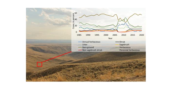
Rangeland Condition Monitoring Assessment and Projection (RCMAP) time-series data provide yearly cover and temporal trends of vegetation conditions since 1985. Data are provided for individual 30-meter pixels and summarized by relevant management units (such as pastures, allotments, and watersheds) on the Multi-Resolution Land Characteristics website.
Disclaimer: Any use of trade, firm, or product names is for descriptive purposes only and does not imply endorsement by the U.S. Government.