The joint U.S. Geological Survey (USGS)--National Aeronautics and Space Administration (NASA) Earth observation Landsat mission began in July 1972 and surpassed its 50th anniversary in July 2022. The 50-year Landsat global data archive comprises eight independently developed NASA multispectral visible-to-shortwave infrared (VSWIR) and thermal infrared (TIR) observatories that have been or are currently operated by the USGS. In ~2014, the USGS and NASA Landsat mission partnership was renewed under what is referred to as the Sustainable Land Imaging (SLI) program. The USGS and NASA SLI program is designed to ensure that the U.S. acquires terrestrial remote sensing observations from space through the 2030s that are compatible with Landsat’s historical global data record to support land and aquatic science, applications, and Federal operational uses. Landsat 9, which launched in 2021 and started operations in 2022, is the cornerstone of the SLI program and planning is already underway for the next Landsat mission.
Remote sensing technology continues to advance with new U.S. and international missions to research and demonstrate the utility of imaging spectroscopy (often referred to as hyperspectral), including recent launches by Italy and Germany. The USGS National Land Imaging (NLI) program, which supports Landsat mission operations, has recognized the need for the SLI program to investigate the usefulness of imaging spectroscopy capabilities and their potential for advancing future Landsat mission concepts and meeting evolving user needs. The Earth Resource Observation and Science Center-Imaging Spectroscopy Project (EROS-ISP) reflects an SLI initiative to inform future Landsat mission concept development toward inclusion of imaging spectroscopy measures as well as documenting the ability to maintain Landsat heritage and data continuity into the future. Thus, EROS-ISP is evaluating all open access sources of airborne and spaceborne imaging spectroscopy data and is using in situ spectroscopy measures to characterize and validate product quality and utility. EROS-ISP is developing a baseline capability to process imaging spectroscopy data using existing computer hardware, licensed and custom computer code, as well as virtual cloud technologies.
A key priority for EROS-ISP is to demonstrate, through a suite of science and application use cases (minerals and geology, cryosphere and hydrology, aquatics and water quality, agriculture, and vegetation ecology), that remote sensing imaging spectroscopy data can complement traditional multispectral Landsat observations, provide added capabilities, and advance science and application value through quantitatively defensible metrics that are peer reviewed.

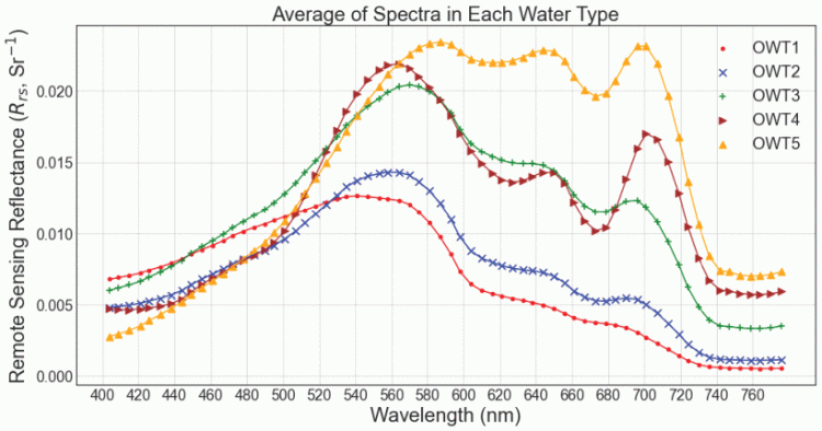
The graphic illustration highlights the importance of spectroscopy sampling methods for distinguishing between optical water types and constituents found within the upper water column.
Disclaimer: Any use of trade, firm, or product names is for descriptive purposes only and does not imply endorsement by the U.S. Government.

