
Microbial biofilm communities, which are comprised of bacteria, diatoms, protozoa, and fungi, inhabit the surface of intertidal mudflats. These communities represent a large proportion of shorebirds’ diets, so understanding biofilm distribution, quantity, and nutritional value supports efforts to manage shorebird populations. A key question in the South Bay Salt Pond Restoration Project, which is the largest tidal wetland restoration project in the western United States, is whether sediment from adjacent mudflats will lead to erosion and potential impacts to biofilm. To address this uncertainty, the project objective is to identify seasonal and spatial variations in biofilm distribution, quantity [chlorophyll-a (chl-a), an indicator of biomass], quality [lipids, total organic carbon (TOC) and glucose content], and community composition through development and scaling of multitemporal, multispectral, and hyperspectral algorithms. This collaboration among the U.S. Geological Survey (USGS) Western Ecological Research Center (WERC), the USGS Western Geographic Science Center, the USGS National UAS Project Office, the USGS Spectroscopy Lab, and California State University Monterey Bay, models biofilm parameters at different scales using data from multiple sources: field spectroscopy; ground-based imaging spectroscopy (HySpex, 5-millimeter resolution); the Resonon Pika-L hyperspectral sensor (4-centimeter resolution), which is mounted aboard an uncrewed aircraft system (UAS); airborne imaging spectroscopy (AVIRIS-NG, 4-meter resolution); and Sentinel-2 (10-meter resolution) satellite data.
Using multiple end member spectral feature analysis, researchers created a time series of biofilm percent cover with Sentinel-2 data. Overall biofilm cover appears highest in the late spring and early summer, then drops off dramatically in the fall and winter months. Researchers generated Sentinel-2 chl-a maps using the soil-adjusted vegetation index, which will be used to identify the best image spatial resolution for biofilm by observing the loss of information as a function of ground sample distance across sensors. The team also produced an AVIRIS-NG chl-a map using continuum removal of the 673 chl-a absorption region and spectral feature analysis. This work is part of a WERC-led project, “Quantifying Drivers and Stressors of Intertidal Biofilm Resources at the Largest Tidal Wetland Restoration on the U.S. West Coast.” Results will support managers’ need to measure and visualize habitat quality for shorebirds and understand the influence of wetland restoration activities on biofilm resources. The associated data release is available here.
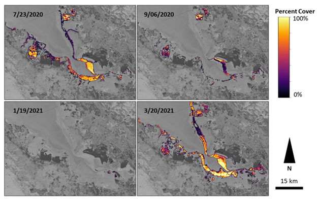
Map of biofilm percent cover by season (summer, fall, winter, spring) in South San Francisco Bay based on multiple end member spectral feature analysis. The associated data release is available here.
Disclaimer: Any use of trade, firm, or product names is for descriptive purposes only and does not imply endorsement by the U.S. Government.