
Barrier islands, headlands, and coastal shorelines provide numerous ecosystem goods and services, including storm protection and erosion control for the mainland, habitat for fish and wildlife, salinity regulation in estuaries, carbon sequestration in marshes, and areas for recreation and tourism. These coastal features are dynamic environments; storms, wave energy, tides, currents, and relative sea-level rise are powerful forces that shape local geomorphology and habitat distribution. To make more informed decisions, coastal resource managers require information about how these dynamic systems are changing through time.
Researchers at the U.S. Geological Survey (USGS) Wetland and Aquatic Research Center have been developing barrier island habitat maps from orthoimagery to observe changes and provide insights for monitoring and adaptive management. A recently completed effort included maps for Whiskey Island and Caminada Headland in coastal Louisiana. The maps cover 2012, 2015, and 2017–2019, spanning the time period before, during, and after large-scale restoration projects were conducted at these sites. In addition to generating habitat maps from orthoimagery, the team mapped shorelines and used satellite imagery to produce general land cover classifications, which included areas mapped as (1) water, (2) bare, (3) herbaceous vegetation, and (4) woody vegetation.
Researchers at the Wetland and Aquatic Research Center and the USGS St. Petersburg Coastal and Marine Science Center have also begun assisting the U.S. Fish and Wildlife Service (FWS) with a long-term monitoring and adaptive management project at Breton Island, the southernmost island in the Breton National Wildlife Refuge in Louisiana. The construction phase of the Breton Island restoration was completed in early 2022 and vegetation planting was scheduled for the fall of 2022. The habitat mapping will include developing a map of the newly restored barrier island.
Collectively, these maps are a powerful tool for tracking habitat changes over time. They are being utilized for numerous applications, including monitoring and adaptive management programs and analysis of avian habitat occupancy and utilization pre- and post-restoration. The maps can be downloaded for both Whiskey Island (2012, 2015, 2017, 2018, 2019) and Caminada Headland (2012, 2015, 2017, 2018, 2019).
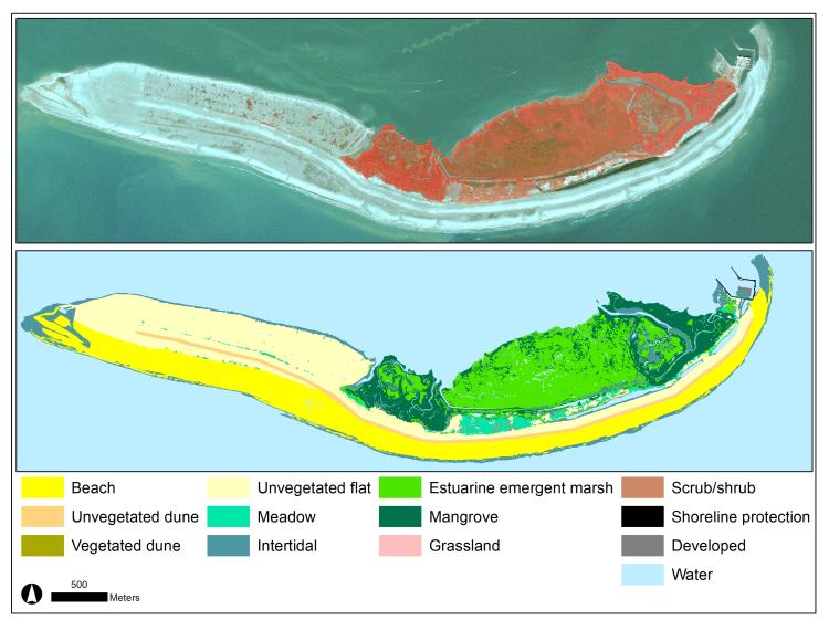
Example of a post-restoration habitat map for Whiskey Island, Louisiana. The top map shows aerial imagery from 2018 and the bottom map shows the habitat map from 2018. The maps are available here.
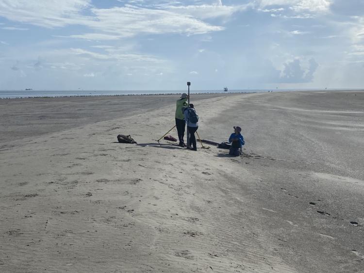
Team collecting post-restoration elevation data in July 2022 on Breton Island, Louisiana. Photo credit: Nicholas Enwright (U.S. Geological Survey).
Disclaimer: Any use of trade, firm, or product names is for descriptive purposes only and does not imply endorsement by the U.S. Government.