
Aerial ocular surveys are the most cost- and time-efficient method of evaluating the relative abundance and spatial distributions of breeding, staging, and wintering waterfowl. However, the survey method is subject to substantial visibility bias, and visibility correction factors must be calculated to correct for incomplete detection. Calculation of these factors in remote or hard to access places, such as open water environments, is difficult, but new technologies offer a solution. To estimate visibility correction factors for waterfowl in open water environments, researchers are using the advanced remote sensing capabilities of the U.S. Fish and Wildlife Service’s Division of Migratory Bird Management. The team will capture high-resolution digital imagery of waterfowl in the open waters of Green Bay in Lake Michigan, Wisconsin; annotate avian species within the images; and compare annotated image counts to ocular counts that will be flown just after image collection. Results of this combined survey will allow for estimation of visibility correction factors and associated uncertainties at variable spatial and temporal scales, exploration of the role density plays in visibility correction factors, and determination of baseline relative abundance and spatial distribution for multiple waterfowl species. Estimation of visibility correction factors is important for agencies conducting aerial surveys over open water environments to assess waterfowl abundance and distributions during the non-breeding period.
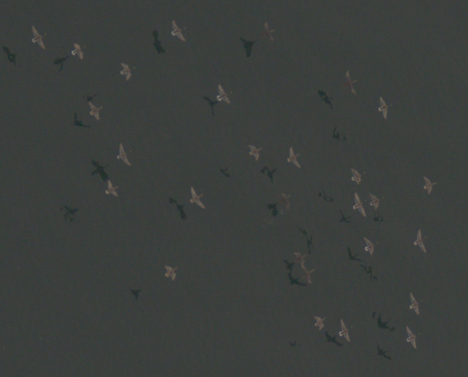
Image of mallards and black ducks taken by the U.S. Fish and Wildlife Service SEABirD Sensor on November 9, 2019 over the open waters of Green Bay in Lake Michigan, Wisconsin. Imagery was collected at 1,000 feet above ground level resulting in an approximate ground sample distance of 1.5 centimeters.
Disclaimer: Any use of trade, firm, or product names is for descriptive purposes only and does not imply endorsement by the U.S. Government.