
Biological soil crusts (biocrusts) are diverse communities of organisms including lichen, moss, and cyanobacteria that live on soil surfaces in dryland environments around the world. Although biocrusts are estimated to make up 12% of the planet’s terrestrial surface and play critical roles in water and carbon cycling, there is great uncertainty related to their distribution, function, and response to change. Researchers at the U.S. Geological Survey (USGS) Canyonlands Research Station maintain a long-term in-situ climate manipulation and biocrust monitoring site near Moab, Utah, to study the effects of a warming climate and precipitation changes on biocrust community behavior and composition. Ground-based measurements including soil moisture, biocrust, vegetation species composition, and gas exchange are collected regularly at plots receiving various temperature and watering treatments. Together, these data offer an unparalleled opportunity to assess biocrusts using multiple ground-based and aerial tools to improve remote sensing capacity for these important organisms.
Remote sensing technologies provide opportunities to scale up observations of biocrust response to environmental changes. In February 2022, researchers from the USGS Canyonlands Research Station, USGS Western Geographic Science Center, University of Arizona Natural Resources and the Environment Department, and the USGS National Uncrewed Systems Office (NUSO) teamed up to collect a series of coincident field-based and uncrewed aircraft systems (UAS) data at the biocrust monitoring plots, and to use these observations to train models of biocrust characteristics across satellite remote sensing data. The USGS NUSO conducted multiple UAS flights carrying six different sensors to collect natural-color RGB (red-green-blue), thermal, multispectral, and hyperspectral remote sensing imagery across the biocrust monitoring plots.
Using this imagery, NUSO generated a series of spectral and structural photogrammetric data products including reflectance orthophotomosaics, digital elevation models, and 3D structure-from-motion point clouds. Ground-based measurements collected during the UAS flights included spectral reflectance profiles of land cover types and biocrust/vegetation species, plot-level thermal and RGB images, soil carbon and nitrogen pool assessment, and gas exchange measurements. Multiple satellite overpasses during the field campaign enabled further cross-scale remote sensing analyses. This research offers a unique look at biocrusts across multiple scales and creates a road map to improve understanding, forecasting, and contextualization of this dominant cover type across the globe.
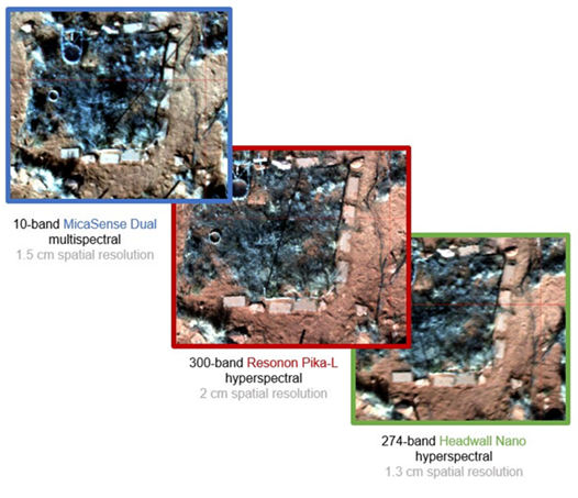
True-color composite images along with the number of spectral bands and the spatial resolution from one multispectral and two hyperspectral sensors used to collect uncrewed aircraft systems (UAS) remote sensing data during this project.
Disclaimer: Any use of trade, firm, or product names is for descriptive purposes only and does not imply endorsement by the U.S. Government.