
The U.S. Geological Survey (USGS) Fire Danger Forecast Program generates several products that forecast the potential for large fires to occur across the conterminous United States. The Wildland Fire Potential Index (WFPI), which quantifies fire risk given fuel and weather conditions, is derived using satellite-based vegetation data, forecast weather data, and land cover classifications. WFPI is combined with historical fire records to generate two probabilistic forecasts: 1) the WFPI-based Large Fire Probability (WLFP), which estimates the likelihood that a fire will ignite and grow to over 500 acres; and 2) the WFPI-based Fire Spread Potential (WFSP), which estimates the likelihood that an existing 1-acre fire will spread and burn over 500 acres. These products are generated daily at a 1-kilometer resolution and forecast out to 7 days. Additionally, the expected number of large fires is estimated for each Geographic Area Coordination Center.
Over its lifetime, the product suite has received several updates. A transition from Advanced Very High-Resolution Radiometer (AVHRR) to the Moderate Resolution Imaging Spectroradiometer (MODIS) was completed after the AVHRR sensor reached its end of life. A similar transition has now been carried out from MODIS to Visible Infrared Imaging Radiometer Suite (VIIRS) imagery in anticipation of the MODIS mission conclusion. The WFPI algorithm itself has been revised to incorporate more weather parameters from the National Weather Service such as wind, temperature, and precipitation. Finally, the program’s web-based data distribution system has been updated with enhanced capabilities and a new user interface.
Work is underway to incorporate snow cover products in both the current and archived forecasts. Furthermore, a comparison between VIIRS- and MODIS-based WFPI is anticipated to validate the forecasts. The latest updates to the forecast products and algorithm are being documented and readied for publication.
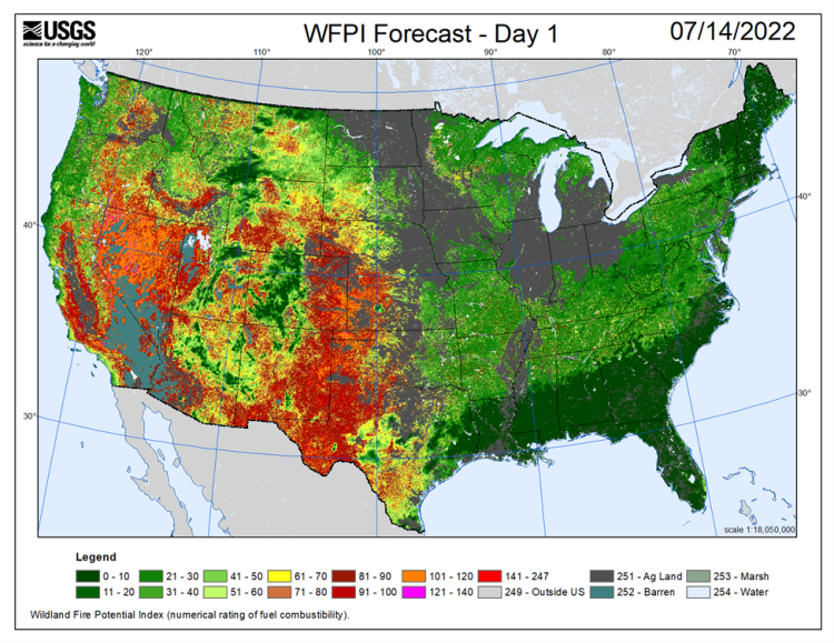
Wildland Fire Potential Index (WFPI) forecast output for July 14, 2022. Higher values (warmer colors) indicate a higher potential for large wildfire activity.
Disclaimer: Any use of trade, firm, or product names is for descriptive purposes only and does not imply endorsement by the U.S. Government.