
The Landsat Collection 2 Level-3 Burned Area (BA) science product enables users to identify burned areas across all ecosystems including forests, shrublands, and grasslands by identifying per pixel burn classification and burn probability in Landsat data from 1984 to present. Using the Burned Area product, Landsat data users can quantify patterns of fire occurrences and project future fire trends.
Several improvements for the Collection 2 BA products include a new browse file added to the product package and a modification that allows for growth in a diagonal direction. For more information and to learn how to download the BA science product, visit Landsat Collection 2 Burned Area Science Product.
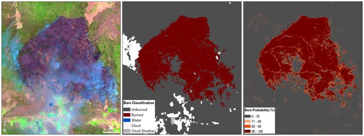
Example of the Landsat Collection 2 Burned Area science product showing the Bootleg Fire in Oregon on July 11, 2021. Left: Landsat Collection 2 U.S. Analysis Ready Data surface reflectance image; Middle: Burn Classification; and Right: Burn Probability.
Disclaimer: Any use of trade, firm, or product names is for descriptive purposes only and does not imply endorsement by the U.S. Government.