
The San Carlos Apache Tribe wants to learn more about the historical characteristics of their woodlands, savannas and grasslands so they have a target for restoration efforts. Restoring juniper woodland to savanna is a focus of the Tribe’s intensive management activities that could be improved with spatial information to help guide restoration efforts. To determine changes in woodland canopy cover, this research developed and applied novel image analysis techniques to monitor tree cover for 3 study areas using 1935 and 2017 aerial imagery and compared results over the 82-year interval. In general, results depict a substantial increase in the woodland tree canopy cover in former savannas and encroachment of juniper trees into grasslands. Additionally, evidence of the success of Tribal woodland management efforts is seen on Bee Flat, where managed landscape canopy cover is analogous to the natural savanna tree cover mapped there in 1935. These results are important as former savanna areas once dominated by native grasses and forbs have been replaced with higher density juniper-pinyon-oak woodlands, with degraded soils and limited herbaceous understories. The San Carlos Apache Tribe intends to use map results from this analysis to locate other woodland areas amenable to restoration and as a current inventory and historical baseline of its Tribal woodlands. Visit a story map about this project created by the Collaborative Conservation and Adaptation Strategy Toolbox (CCAST) Team.
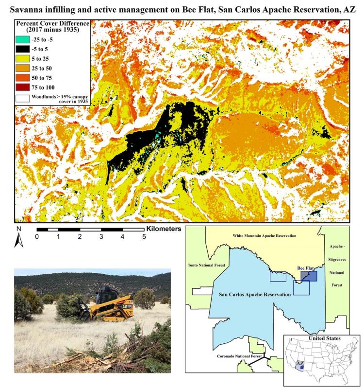
Image portrays the dramatic increase in woodland cover over 82 years in former savanna environments on the San Carlos Apache Reservation lands of east-central Arizona and highlights the initial success of the Tribe's savanna restoration efforts. The associated publication is available here. Photo credit: Barry Middleton (U.S. Geological Survey).
Disclaimer: Any use of trade, firm, or product names is for descriptive purposes only and does not imply endorsement by the U.S. Government.