
The USGS is advancing the development of machine learning algorithms to detect and classify seabirds, waterfowl, and other marine wildlife from digital aerial imagery in collaboration with Bureau of Ocean Energy Management, U.S. Fish and Wildlife Service, and the Vision Group at the International Computer Science Institute. Improved sensor, computing, and image processing technologies offer promise in enhancing the safety, cost efficiency, and quality of derived data for wildlife population surveys used by natural resource management agencies. Initial machine learning algorithm development has achieved the extraction of targets (individual birds and other wildlife) from imagery; subsequent algorithm development will focus on identifying relevant attributes (i.e., species, sex-age cohort or plumage category, and activity, when resolvable) of detected targets. Algorithm performance based on image and environmental characteristics (e.g., spectral resolution, background water color, sea state, cloud cover, etc.) is being tested to maximize detection and classification accuracy. This project also involves the development of an online feature annotation tool (based on an open-source annotation tool CVAT - Computer Vision Annotation Tool) for easy, streamlined labeling of training data by biologists and to serve as an imagery and annotation database for online data archiving and sharing. These products are intended to provide baseline information on wildlife distributions, abundance, and seasonal movement to inform migratory bird harvest assessments, environmental assessments, and impact analyses of potential wildlife exposure to offshore energy development projects. While digital aerial imagery collection for this project has been targeted along the Atlantic Outer Continental Shelf and the Great Lakes, these processes, algorithms, and associated tools and databases are intended to be applicable across a range of taxa and environments.
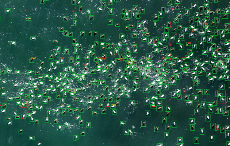
Machine learning–generated bounding boxes around bird targets (common eiders offshore Cape Cod, Massachusetts), colored by confidence of prediction [Confidence: Green – High, Yellow – Moderate, Red – Low].