
In 2020, the USGS released new image data products for monitoring land surface change from 1985 to 2017 across the conterminous United States. The Land Change Monitoring, Assessment, and Projection (LCMAP) initiative Collection 1 data release is a major milestone toward LCMAP’s goals of developing the capability to detect and characterize historical land change, producing a suite of validated annual land change/land cover maps and area statistics, and modeling past and future land change outside the current satellite record.
The power of the Landsat archive is leveraged through use of U.S. Landsat Analysis Ready Data (ARD), containing the highest quality radiometric and geometric 30-meter Landsat data processed to a consistent format. A time series of all available cloud/shadow-free observations serves as input for the Continuous Change Detection and Classification (CCDC) method, which builds per-pixel harmonic time series models of surface reflectance for each Landsat spectral band individually. The model predictions are continuously compared to actual observations over time to detect statistically significant differences across multiple bands representing land surface changes. Following identification of changes, boosted decision tree machine learning is applied to model coefficients to classify land cover type. The application of ARD and CCDC provides a systematic and consistent capability revealing land change from the mid-1980s to the present at 30-meter resolution.
LCMAP Collection 1 science products include 10 annual land change and land cover map products for the time period 1985–2017 granularized to the 150x150 kilometer ARD grid and are available from USGS EarthExplorer. Independently collected LCMAP Reference Data of 24,971 random locations were used to validate land cover accuracy across the full spatial and temporal extent, with a final 82.5% agreement. The Reference Data, along with annual and regional accuracies, are available from USGS ScienceBase. Additional assessments of map bias and area statistics are underway, as is the development of methods to update LCMAP outputs; product updates through 2019 are expected in the coming year.
The USGS is defining requirements for additional capabilities such as monitoring change with lower lead times in rapidly changing areas, improved sensitivity for change detection, identification of specific types of change, and development of monitoring capabilities to alert relevant land managers to important changing conditions. The LCMAP Collection 1 data release and other capabilities of LCMAP enable the USGS to meet increasing demands for timely and frequent integrated land cover and land change information.
https://www.usgs.gov/land-resources/eros/lcmap
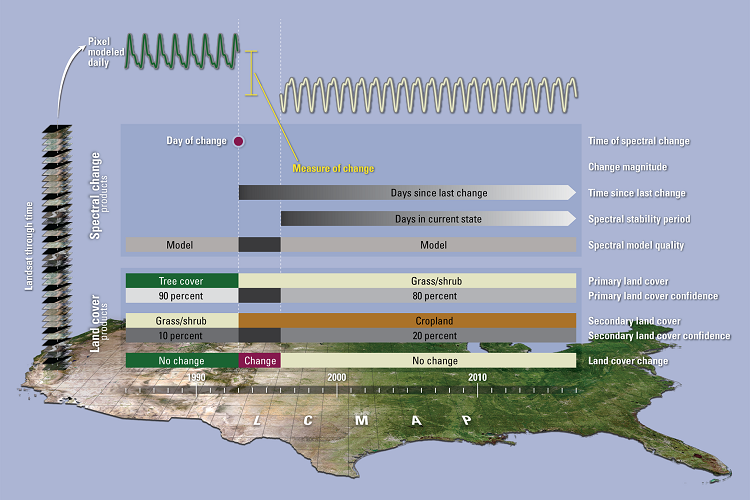
Schematic representing the LCMAP approach from input U.S. Landsat ARD, to time series models, to LCMAP Science Products.