
The presence of water in streams can serve as an indicator for potential droughts. The National Hydrography Dataset (NHD) is the most comprehensive dataset of surface waters in the United States and supports a broad range of applications. The streams mapped in the NHD are classified by streamflow permanence into classes of perennial, intermittent, or ephemeral. However, this information is often based on methods such as field measurements and visual interpretation of aerial images, which are time-consuming and costly, making the information difficult to maintain. The NHD also does not consistently track natural or human-caused increases and decreases in streamflow over time. Satellite data from commercial satellite constellations generated by both Maxar and Planet provide coverage at unprecedented spatial and temporal resolutions, offering the potential to improve data about the presence of water in a stream channel. However, a novel approach involving automation provided by machine learning (ML) is required to analytically harness these immense data volumes.
USGS is partnering with the Waters of the United States Frontier Development Lab (FDL) Challenge, which aims to employ modern ML approaches to detect water presence on daily high-resolution satellite images and to apply that information to stream mapping. This project seeks to provide daily stream network water presence for four pilot areas in Colorado, Idaho, Oregon, and South Dakota to establish a proof of concept for rapid, automated stream identification and categorization as a function of time. This approach will then be used to create a dataset and interface to display nearly real-time data that can be used in water availability forecasts, ultimately helping to predict droughts. If the approach is successful, it will be applied in additional areas with plans to ultimately expand nationally and beyond. FDL is a public-private partnership with the National Aeronautical and Space Administration (NASA) in the Unites States and ESA in Europe. FDL brings together some of the brightest minds from space science, AI, and the commercial sector and receives support from NASA HQ, NASA ARC, NASA MSFC, the SETI institute and commercial AI partners Google Cloud, IBM, Intel, and NVIDIA. USGS is providing mentoring, expertise, hydrographic information, 3D Elevation Program light detection and ranging (lidar)-derived vegetation layers, and other training data for FDL scientists to use in their ML routines.
https://frontierdevelopmentlab.org/fdl2020
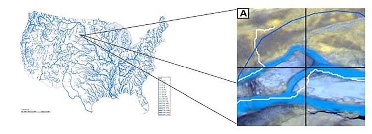
Image of NHD (left). Inset A (right) imagery showing water presence, NHD lines (blue) and synthetic streamlines (white).