
Historical quantification of invasive grass cover in the Great Basin provides a spatiotemporal 30-meter resolution data cube that can be mined for the environmental envelopes associated with cheatgrass (Bromus tectorum) invasion, and environmental envelopes for cheatgrass tipping points, trends, and post disturbance (fire) succession trajectories. Previous work produced a 250-meter cheatgrass cover time series back to 2000 driven by Moderate Resolution Imaging Spectroradiometer (MODIS) weekly Normalized Difference Vegetation Index (NDVI). With the advent of harmonized Landsat/Sentinel-2 data, researchers developed weekly cloud-free growing season NDVI data, which were a major spatiotemporal input to map invasive grass cover (> 60% of this is cheatgrass) as quantified by Bureau of Land Management (BLM) Analysis, Inventory, and Monitoring (AIM) field plots (black dots in the figure). The predictions from the data mining model of invasive annual grasses had a mean absolute error of 11% cover and were used to map invasive annual grass cover at 30-meter resolution from 2016 to 2019. The top three most heavily used inputs to the model were NDVI from week 16, NDVI from week 11, and elevation. An interannual mean absolute error map was found to be a useful input in the subsequent near-real time invasive annual grass map. Future plans are to extend this invasive annual grass mapping to rangelands within the gray shaded area in the figure (“Homer’s shrubland AOI”).
https://doi.org/10.5066/P9XT1BV2
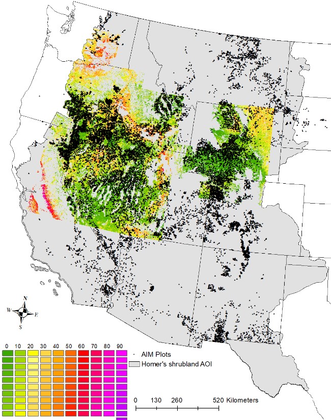
Invasive annual grass cover mapping in the central western conterminous U.S. showing Bureau of Land Management (BLM) Analysis, Inventory, and Monitoring field plots and planned 2021 mapping expansion (rangeland within the gray shaded area).