
The mapping and monitoring of land use and land cover (LULC) is invaluable for interdisciplinary studies assessing impacts of LULC change on hydrology, climate and regional weather, biodiversity, and many other applications. Remote sensing provides consistent, synoptic, and repeatable data coverage for LULC monitoring, with USGS and partner agencies using the historical Landsat archive for national-scale monitoring programs such as the National Land Cover Database (NLCD) and the Land Change Monitoring, Assessment, and Projection (LCMAP) project. However, monitoring programs are limited to the temporal time span for which adequate remote sensing data are available. Availability of consistent LULC data for historical periods (prior to availability of remote sensing data) facilitates an understanding of past relationships between LULC change and biophysical and socioeconomic consequences, while projections of future LULC conditions facilitate future planning and mitigation activities.
USGS developed the Forecasting Scenarios of land use (FORE-SCE) model to “temporally extend” remote sensing-based LULC databases for both historical and future time periods. The model relies heavily on remote sensing-based databases such as NLCD or LCMAP for model parameterization and development of future scenarios. FORE-SCE has been applied in the Delaware River Basin to produce a long-term reconstruction of historical LULC conditions, as well as multi-scenario projections of future conditions. A parcel-based modeling approach was used, using real land ownership and land management parcels to effectively mimic landowner decisions at the local scale and across the entire Basin. Historical demographic data, agricultural census data, information on wetland extent and reservoir construction, and other data were used to reconstruct historical landscapes, while multiple future scenarios were modeled to represent uncertainty in future landscape conditions. Both the LULC reconstruction and the future projections used thematic classes that not only matched NLCD but modeled major crop classes in the region (consistent with major crops represented by U.S. Department of Agriculture’s Cropland Data Layer (CDL)). The resulting database provides LULC maps at 10-year increments from 1680 through 2100, providing spatial and thematic consistency with NLCD and CDL and facilitating applications already reliant on those benchmark datasets. Work continues in the Delaware River basin on linking FORE-SCE landscape projections with hydrologic and evapotranspiration models in the region, moving us toward a true parcel-based water accounting framework that captures and models interactions among land use, water use, water availability, and climate.
https://www.usgs.gov/land-resources/eros/lulc
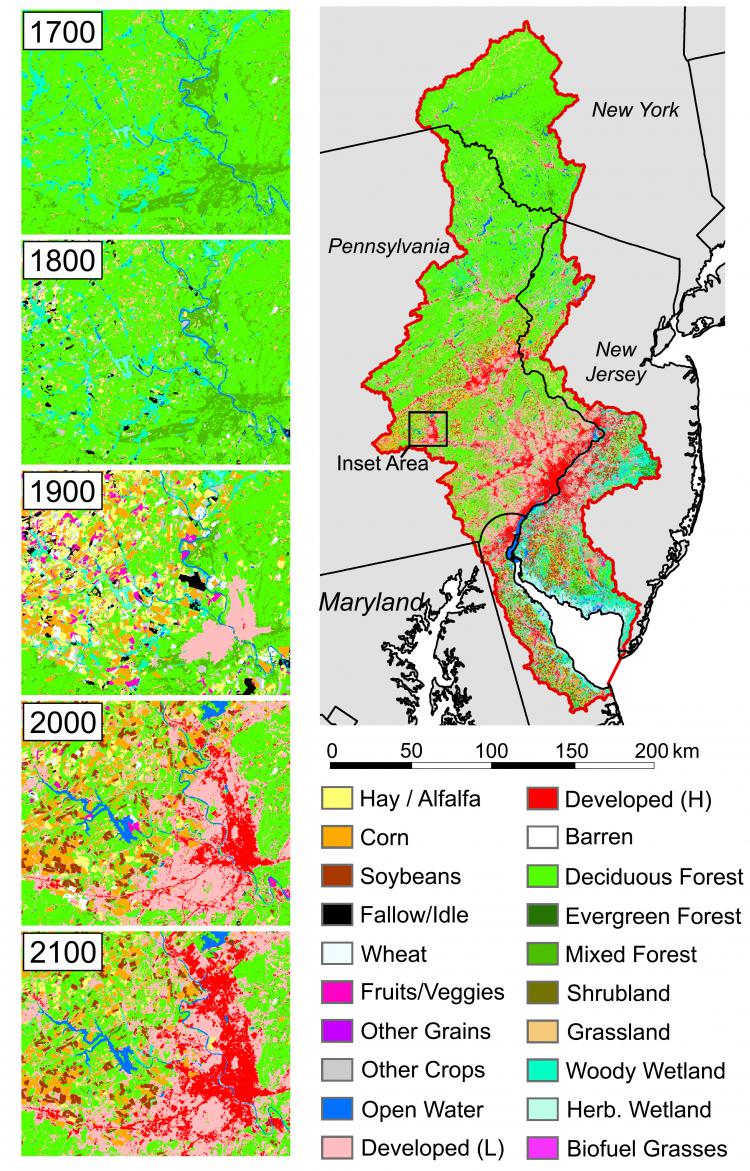
Modeled land cover for the Delaware River Basin from 1700 through 2100. The modeled future scenario from 2016 through 2100 was based on a “business-as-usual” scenario.