
Wetlands and surface waters are critically important for both natural and anthropogenic processes including climate regulation, the maintenance of biodiversity, and the provision of ecosystem services important for human well-being. Until recently, mapping the spatial and temporal variability of the Earth’s surface waters and wetlands would have been an impossible task. However, with advances in remote sensing, cloud and high-performance computing, the ability to discern trends and continuously monitor and map the Earth’s surface has emerged. Using Google Earth Engine (GEE) and a Landsat imagery series beginning in 1985, this project is supporting land management applications of the Department of the Interior by increasing the ability to monitor and map the dynamics of surface waters and wetlands, monitor in near-real time the inundation of surface waters, and understand how the dynamics and variation in inundated area influence carbon storage and greenhouse gas accounting.
This project is also generating new remote sensing methods. In addition to producing dynamic surface water extent (DSWE) products, this project has developed a novel water delineation index with dynamic thresholding that classifies with higher accuracy compared to its predecessors. This index performs successfully under various climatic and land surface conditions where traditional methods have failed (e.g., hot water, dust obscured, shadow, cloud cover). A new cloud filtering algorithm for GEE is proposed that refines the cloud masking and percentage-based cloud filtering approaches. Finally, an automated GEE is in development for delineating water surfaces and creating monthly time series of water body surface areas for a user’s area of interest.
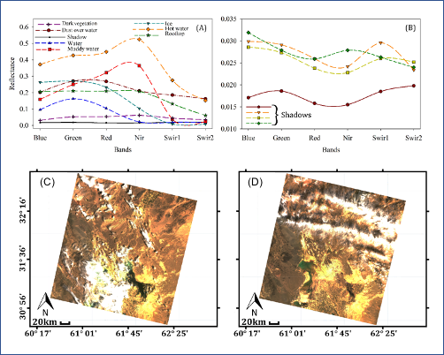
Spectral reflectance patterns of different land surface features that often confuse water delineation methods, using cloud-free (A) or within shadow (B) data collected from Landsat 8 imagery. Filtering images based on the percentage of cloud cover for an unusable scene for water delineation from Landsat 8 with 24.6% cloud cover (C) where a lake is obscured by clouds, or (D) a usable scene from Landsat 8 for water delineation with 34.5% cloud cover where the lake is not obscured by clouds.