
Mercury is a contaminant of concern in the San Francisco Bay and the Sacramento–San Joaquin Delta (Bay-Delta) estuary and watershed. The USGS California Water Science Center and USGS Earth System Processes Division (Water Mission Area) are working with the University of California, Merced, to combine in situ and remote-sensing data to model mercury and methylmercury concentrations at high spatial and temporal resolution in surface water of the San Francisco Bay-Delta estuary. An impediment to addressing this concern is the lack of sufficient water-quality data collected at the spatial scale and temporal intervals necessary to understand hydrodynamic and biogeochemical processes controlling exposure to mercury and methylmercury, a toxic organic form of mercury that is a readily bioaccumulated. In large water bodies and complex ecosystems such as the Bay-Delta, traditional approaches to water-quality monitoring rely on the collection of discrete water samples. This approach is labor-intensive, expensive, and typically results in low spatial and temporal data density. Recent advances in both remote-sensing platforms and deployable in situ water-quality sensor arrays have dramatically increased the ability to collect data at higher spatial and temporal resolution. Recent efforts have focused on linking discrete data with in situ and remote-sensing data to model surface-water mercury and methylmercury concentrations at high spatial and temporal resolution to a degree not previously achievable. Several recent and ongoing studies have leveraged this capacity for high-resolution monitoring of in situ water-quality parameters (e.g., turbidity, fluorescent dissolved organic matter, chlorophyll, and flow) coupled with traditionally collected (lower resolution) data for mercury and methylmercury in discrete surface-water samples, and remote sensing platforms including Landsat 8 and Sentinel-2. Field sites include the south San Francisco Bay salt ponds restoration area, the Grizzly Bay / Suisun March region, and the Delta region. This work is funded through the California Department of Fish and Wildlife from the Water Quality, Supply, and Infrastructure Improvement Act of 2014 (CWC §79708[g]).
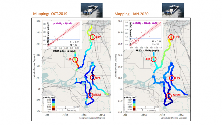
Maps showing the modeled concentrations of particulate methylmercury (pMeHg) throughout the 3-day mapping transect data collection using the underway data collection platform during October 2019 (left, using turbidity as a proxy) and January 2020 (right, using turbidity and latitude). The models shown are preliminary and for demonstration purposes only. Robust models will be developed between in situ and laboratory measurements, which will allow estimation of the filtered and particulate concentrations of total Hg and methylmercury (fTHg, fMeHg, pTHg, and pMeHg), and spectra from satellites, which would allow these water-quality parameters to be estimated and mapped throughout the delta at various temporal and spatial scales. Red circles indicate fixed stations where continuous in situ data are collected, and where Hg and MeHg species are sampled over tidal cycles.