Mangroves are among the most carbon rich forests globally and they provide numerous ecological and economic services such as coastal erosion protection, water filtration, and breeding grounds for fish. These coastal ecosystems are among the most threatened and vulnerable worldwide and have experienced a dramatic decline during the last half century. Better scientific understanding of the rates, patterns, causes, and consequences of mangrove change is needed.
The overall goal of this project is to assess mangrove vulnerability to climate change and land use change and to understand effects of the changes on mangrove carbon storage and sequestration. Information generated from this project will help answer questions such as, 1) how are the structure, density, and health of mangrove forests changing, and 2) what management interventions are needed to maintain or improve forest vigor and health.
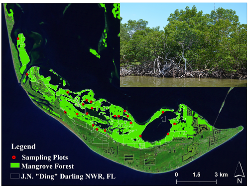
The study components include 1) remote sensing data collection, 2) data analysis (classification and change detection implementing Vegetation Change Tracker (VCT) and Land Change Monitoring, Assessment, and Projection (LCMAP) techniques) and accuracy assessment, and 3) permanent plot establishment for aboveground biomass (AGB) and future carbon sequestration estimates. The J.N. “Ding” Darling National Wildlife Refuge, Florida, is being used as a pilot project, and methodology and lessons learned will be applied to other areas. A similar project is being carried out on the island of Pohnpei, Federated States of Micronesia, in collaboration with the U.S. Fish and Wildlife Service as well as the Micronesia Conservation Trust and the Conservation Society of Pohnpei.
Research results will be useful for managers to identify and reduce the vulnerability of mangroves (and possibly other coastal wetland types) and their carbon stocks to climate change. Mangrove biomass will be measured using species-specific allometric equations. Afterward, mangrove aboveground carbon (AGC) will be obtained, and the carbon stock of each mangrove stand will be summed to obtain the total mangrove AGC in each sample plot. Each pixel in Landsat observations will be utilized to extrapolate the sample point biomass observations.

Location of permanent sampling plots for measuring aboveground biomass at J.N. “Ding” Darling National Wildlife Refuge, Florida.

