The USGS Land Remote Sensing (LRS) Program is partnering with Federal agencies to document user requirements for Earth Observation (EO) data and the benefits that these data provide to Federal programs. The Requirements, Capabilities, and Analysis for Earth Observation (RCA-EO) project was established to help the USGS and other federal agencies take full advantage of United States and international EO capabilities, and develop requirements-driven, prioritized investment decisions for new EO systems, products, and services.
The USGS RCA-EO project, along with the National Oceanic and Atmospheric Administration (NOAA), has jointly developed a unified database-driven information infrastructure and analysis suite called the Earth Observation Requirements Evaluation System (EORES) to support Requirements, Capabilities and Analysis.
The RCA-EO project elicits stake holder needs to document: (1) Requirements: What needs to be observed, such as land surface temperature or vegetation condition, including where and when it is needed and how accurate it must be; (2) Capabilities: What EO capabilities exist or are needed to satisfy the requirements, including what is observed, where it is observed, how often, and how accurately. RCA-EO utilizes these requirements and capabilities stored and managed in the EORES along with additional tools to perform (3) Analysis: What activities exist or can be designed to help guide management decisions by those who manage or develop EO systems, products, and services, and to help users of these same products and services.
During the past year, RCA-EO made considerable progress on EORES and within all three focus areas. (1) Requirements: Completing the value-tree information (VTI) elicitation for the USGS (including 27 programs, over 500 subject matter experts, and 345 key products and services), and making excellent progress eliciting user Requirements. (2) Capabilities: Completing the initial population of the capabilities database; (3) Analysis: Establishing an operations concept and workflow for analysis. Additionally, RCA-EO made excellent progress on development of the EORES application, which will have met initial baseline operational capability this year. RCA-EO data and infrastructure has provided substantial support to the USGS as well as the Administration’s National Plan for Civil Earth Observations and the associated current Earth Observation Assessment 2016. RCA-EO information analyses will continue to help the USGS inform decisions for future land imaging missions and EO science pursuits.
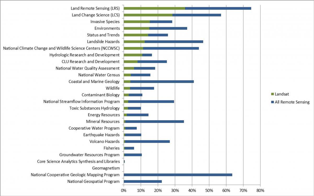
From a national perspective, RCA-EO analyses will provide a better understanding of EO systems and their benefits to society, and can inform the development of more responsive and cost-effective EO systems. Preliminary results are shown below, summarizing the impact of remote sensing on USGS programs and the usage of Landsat within the USGS. Understanding user community needs and capturing their enduring user requirements is a critical step toward developing a way forward in the world of Earth observation systems.
RCA-EO project videos and information can be viewed at http://remotesensing.usgs.gov/rca-eo/.

The contribution of remotely sensed data for research conducted in the USGS programs. Landsat data are shown as a subset of total data use.

