Shrub and grassland ecosystems in the western United States are especially prone to fire events, yet available data for assessing fire risk in these areas are inadequate. Part of the difficulty in effectively characterizing shrub and grasslands for fire applications is related to the high degree of intra- and inter-annual variability of fuel characteristics in these ecosystems. A better understanding of the dynamics of these ecosystems and the conditions that promote wildfires needs to be developed. This information is of special importance to projects that are providing fire managers with nationally consistent and detailed spatial information about vegetation and fuel structure.
Through the support of the NASA Applied Sciences Program, staff at the USGS Earth Resources Observation and Science (EROS) Center embarked on an assessment to derive better fuel characterizations in western United States shrub and grassland ecosystems. The primary objectives of the first phase of the project included the following: (1) improve shrub and grassland mapping for fire applications; (2) develop intra-seasonal fuel datasets in shrub and grassland areas using a combination of Landsat and Moderate Resolution Imaging Spectroradiometer (MODIS) data; and (3) determine if improvements in shrub and grassland data layers will alter and improve fire behavior model results.
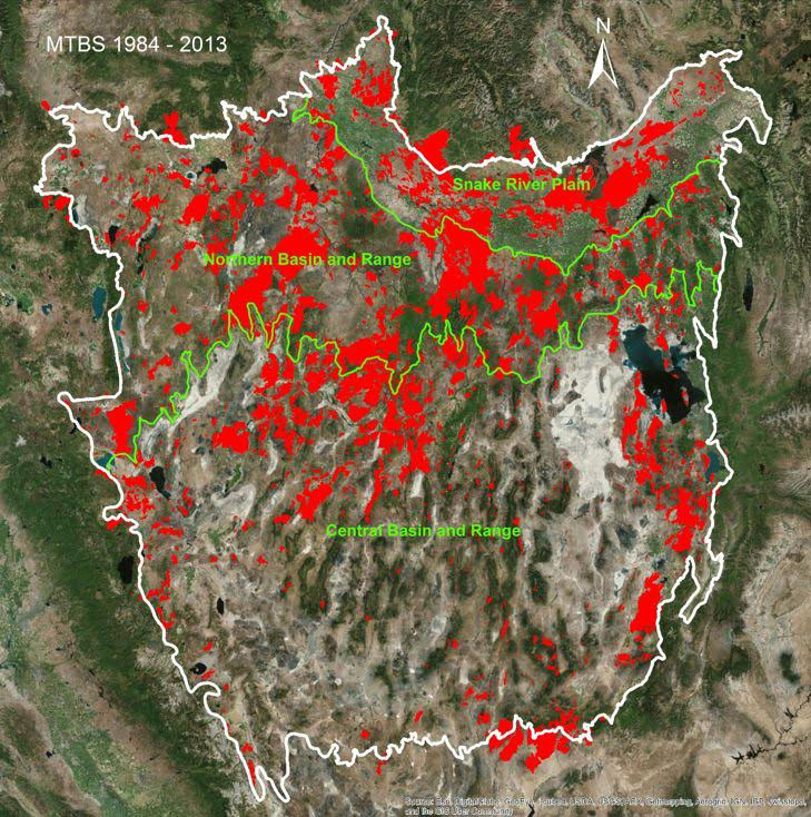
The current focus is on the Great Basin, which includes portions of Nevada, southern Idaho, and western Utah. This area is the site of many large and frequent shrub and grassland fires. The shrubland areas are dominated by sagebrush, while the grassland areas have a substantial amount of invasive cheatgrass associated with them. The shrub and grassland areas of the region are characterized by high levels of biomass variability detectable through time series data analyses from MODIS. Those areas that have burned recently tend to have higher levels of biomass than those that have not. Understanding these patterns helps the fire management community recognize which areas have high likelihood of burning in the future, thus enabling them to anticipate and plan accordingly.
The project is currently developing methods to merge Landsat with MODIS data throughout the region. The high spatial resolution of Landsat is desirable for fire modeling applications, while the MODIS sensor provides high temporal frequency data that enables insight into seasonal dynamics. Merging Landsat and MODIS data provides the beneficial aspects of both imagery datasets and will help to better understand the patterns of green-up and senescence at spatial scales desired by the fire management community.

Red indicates areas burned at least once during 1984–2010 within the Great Basin. Most of the burned areas are located in shrub and grasslands. The northern portion of the region (especially within the Snake River Plain and the Northern Basin and Range ecoregions) had proportionately more fires than the southern portion of the region. This information is useful for helping predict which areas are most likely to burn in the future.

