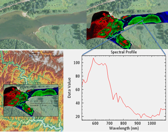
Working in cooperation with the National Park Service (NPS) and the Western Pennsylvania Conservancy, USGS scientists are utilizing hyperspectral data from the Civil Air Patrol (CAP) ARCHER (Airborne Real-time Cueing Hyperspectral Enhanced Reconnaissance) to map submerged aquatic vegetation, along with the invasive algae Didymosphenia geminata (didymo), in the Delaware Water Gap National Recreation Area and Upper Delaware Scenic and Recreational River. The overall goal of this investigation is to evaluate vegetative species composition and extent, as well as emerging threats to the lotic (i.e., flowing water) ecosystems in these parks. Assessments of aquatic vegetation and algae are important for monitoring riverine ecosystem integrity and can alert NPS managers to water quality degradation and eutrophication from upland land uses outside the park boundary. Aquatic vegetation serves as a food source and microhabitat for stream invertebrates and provides critical feeding and cover habitat for fish; it also helps to slow flowing waters, filter sediment, and remove nutrients from the water column. One complication with using visible and near-infrared (VNIR) hyperspectral remote sensing data in this project is that water strongly absorbs infrared energy. The unique application of hyperspectral data will serve to answer several key questions about the health of the park’s ecosystems and help assess the viability of VNIR hyperspectral data in this complex scenario.
http://water.usgs.gov/watercensus/delaware-dss.html

Hyperspectral analysis of the water column shows submerged aquatic vegetation and the possible invasive aldae, Didymosphenia geminata, near Buckingham, Pennsylvania. All images are oriented with north at the top.

