In the arid Southwest, much remains unknown about how migratory birds use different habitats when they stop to rest and refuel during migration. The relatively unpopulated and remote expanses of the West present logistical and cost challenges to field-based studies of migration ecology. USGS scientists at the Fort Collins Science Center (FORT) and the Northern Rocky Mountain Science Center turned to data collected remotely by weather surveillance radars (WSR-88D) and satellites (land use and land cover data from the USGS National Map Seamless Server). These data sources were used to calculate the densities and distributions of migrating birds using different stopover habitats across the southwestern United States. Results indicate parts of Arizona and New Mexico upland forest support high densities of migrants as do human-developed habitats located in areas with little upland forest. Scrub/shrub and grassland habitats support low to intermediate densities, but because these habitats dominate the southwestern landscape, they may support larger numbers of migrating birds than previously recognized. These results are important to those working to conserve migratory birds in the Southwest.
Radar echoes superimposed over simplified land cover around the Tucson, Arizona radar (white dot), May 14, 2005, 19:47 MST. Upland forest is shown in white with all other land cover types in gray. Voids in the radar data occur in forested areas where mountain peaks interfered with the radar beam; these mountain ranges are labeled - (A) Santa Catalina Mountains, (B) Rincon Mountains, and (C) Huachuca Mountains. Strong radar echoes are denoted by red/purple colors and indicate high bird densities as they take off to initiate further migration. High bird densities are associated with the upland forest habitat characteristic of tall mountain peaks.
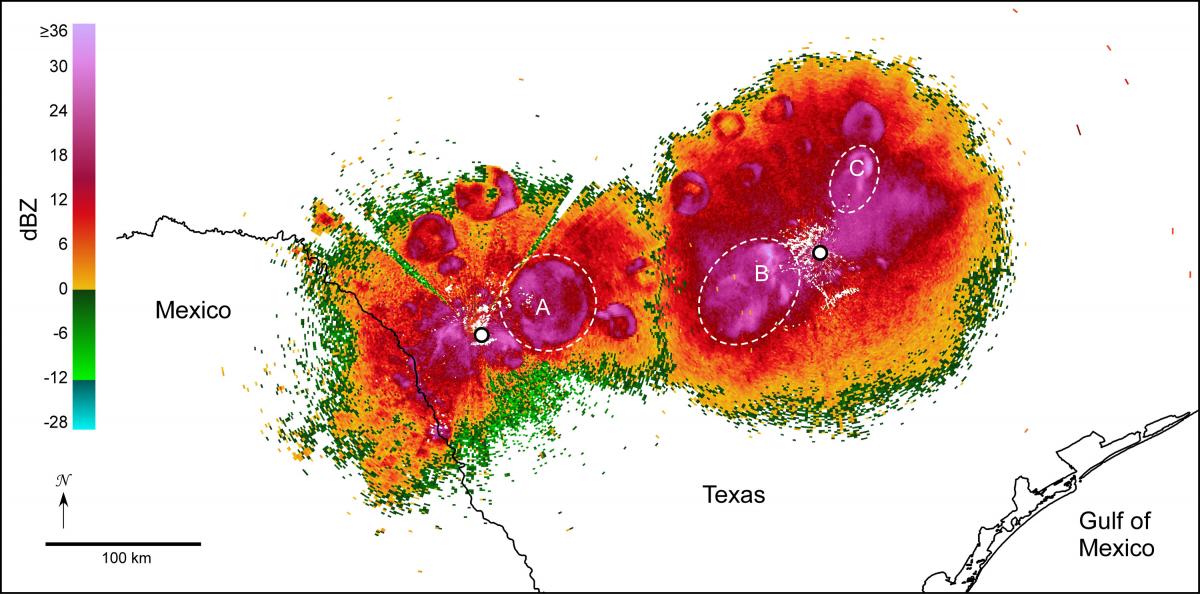
Radar detects more than birds. While mapping migrating birds in the borderlands, weather radars in central Texas (white dots), documented circular and semi-circular patterns of echo characteristic of Mexican free-tailed bats departing cave roosts (in this case, on the evening of October 14, 2005). Red/purple colors indicate high bat densities. Dashed circles highlight noteworthy bat emergences from Frio Cave (A), Bracken Cave (B), and the Congress Avenue Bridge in Austin, Texas (C). Many other roosts are visible in this image.


