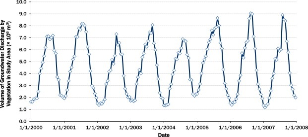
Scientists from the USGS and the University of Arizona developed a method of estimating basin-scale groundwater discharge by vegetation using remote sensing data from satellites and GIS land cover and stream location information. The method uses a regression equation developed within the 190,000-km² southern Arizona study area relating the Enhanced Vegetation Index from the MODIS sensors on the Terra satellite to measured evapotranspiration. The figure below provides an example of the estimated groundwater discharged by vegetation across the study area over 8 years utilizing 16-day composited MODIS satellite passes.

Volume of estimated groundwater discharge by vegetation for the study area for 16-day composited MODIS satellite passes.

